AN EXOTIC DESTINATION IN THE MED: SARDINIA EAST COAST
From Tavolara and Molara Island throw the Gulf of Orosei where from South to North, beaches flow in this order: Cala Goloritze, Cala dei Gabbiani, Cala Mariolu, Cala Biriola, Cala Sisine, Cala Luna, Grotte del Bue Marino, Cala Gonone.
This is one of the few places in the Mediterranean that hasn’t been disrupted by construction and mass tourism. This is an exclusive, peaceful location, sheltered from crowds, noise and prevalent winds.
WHICH PART OF SARDINIA IS WORTH VISITING?
We suggest you to visit at least one of this fantastic spots in Ogliastra, where to anchor without any particular restriction. 20 miles of untouched wild beaches and grottos backed by steep limestone cliffs meeting turquoise blue water, where land access is almost impossible except for a couple of beaches.
Starting from southern Olbia The National Marine Park of Tavolara offers a good anchorage at Cala Spalmatore on sand, and a must-do surely is to dive and snorkel off Molara’s Island
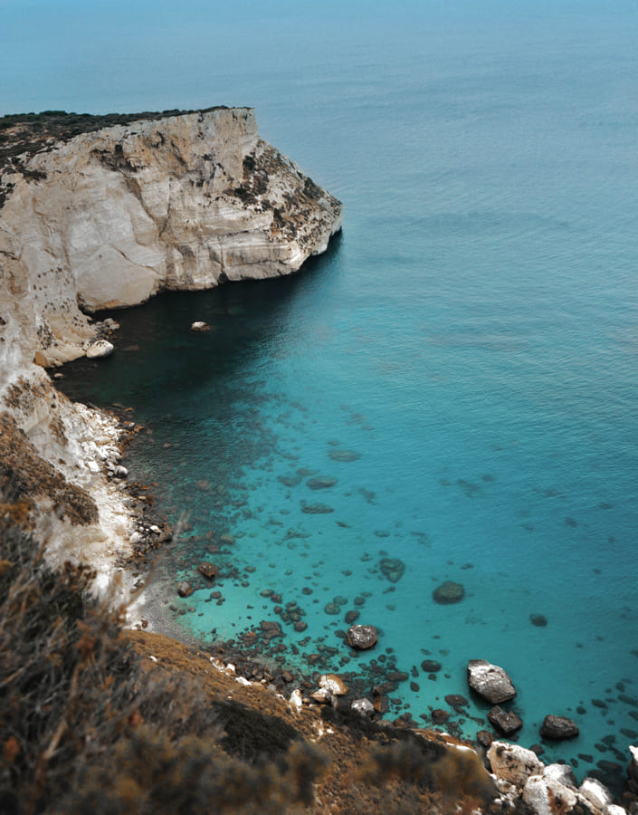
Heading South towards Orosei's Gulf the very first beautiful bay is Cala Luna (Coordinates: 40°13'35"N 9°37'35"E) with it’s small private coves separated from the main beach with cliffs and can be reached only by boat. Famous for the sandy beach, which is rock-bound by the limestone cliffs and caves.
Then very close is Cala Sisine (Coordinates: 40°10'45.3"N 9°38'03.3"E). Get there at early hours in the morning when the pebbles beach offer the best colors. Better admire it all from the boat and have a bath away as it’s really uncomfortable laying on the beach and practically painful getting into the water.
The famous Cala Goloritzè is a must to be seen!!!! (Coordinates: 40°06'36.3"N 9°41'21.2E) A Terrific bay! It is spectacular you can’t get to the beach by boat, but only hiking or swimming 300 meters.
In 1995 it was elected "Italian National Monument" and it is the most photographed beach in the Ogliastra area. The bottom is clear even if it’sand 30 m. high. Check it out!
Cala Mariolu (Coordinates: 40°7'27.448"N 9°40'34.158"E) sand and pebbles beach. It has cliffs from which you can jump into the blue waters.The bottom is rocky and suitable for scuba diving and snorkeling fishes. Some rocks emerge from the sea and form tiny islands.
Last but not least: it comes Cala Biriolu (Coordinates: 40° 9' 44.680" N 9° 38' 53.286" E) this beach is the hidden gemstone. Just around the corner of Cala Sisine. The famous little stone arch over the sea characterized this place. A stunning orange shade sand mixes with white pebbles junipers and the maquis on the rocks. Once you are there, nothing matters; the only willing is to stare into the crystal clear turquoise waters. Perfect place for people keen on scuba diving.
Very important tip: if you plan visiting the beaches, remember that they are backed by high cliffs and after 3pm sun starts setting down, therefore some of the beaches stays in the shadow. Cala Sisine and Cala Luna should be the last to be visited, as sun stays longer.
WHAT ARE THE MUST SEE SPOTS IN OGLIASTRA?
The caves at Grotta del Bue Marino and Grotte di Ispinigoli, which really worth a visit by tender - we can always organize private tours- as they have some of the tallest stalagmites in Europe. Cala Gabbiani practically an empty beach visited mostly by locals. Long yellow sandy beach with the typical clean blue waters. It is worth a visit. If you have time Is Putzu only 50 meters from Cala Goloritze.
INLAND EXPERIENCES IN OGLIASTRA: TREKKING TISCALI
Only for braves: 4×4 tour throw the deep canyons open in the Supramonte of Lanaitto Valley, including also a stop at the Grotto Corbeddu - the location of findings that wrote the history of human inhabitation of the area.
Sport & History: a trek at Tiscali. Located in a deep depression created by a deepening in the heart of the mount. The Nuragic village of Tiscali, built along the walls of the depression and invisible until you get to the inside of the cavity, consists of two ensembles of dwellings of various sizes, built and inhabited between the 15th and 8th centuries BC. Their origins are mysterious: the building technique is very different from those of other Nuragic sites.
Another unmissable visit is: Su Gorroppu, a gorge created from erosion it’sthe most spectacular canyon in Europe and it is also one of the deepest. The width of the gorge varies from a few dozen meters to just four meters. It is the wildest territory on the Island, a natural monument, thanks to its biodiversity and the endemism of plant and animal species.
Lunch at su Gologone Hotel restaurant, then take a walk to the most important karstic spring in Italy: Su Gologone, a national monument. The main source for the vast Karst system of Supramonte. Over the millennia the water has carved out meandering underground channels before reappearing above ground as a small lake, set between the high walls of Dolomitic rock. The tones of water vary from emerald green to turquoise and intense blue, according to the reflection of the sun. The clear, deep water is an irresistible challenge for underwater cavers, who arrive here from all over the world: in 2010, Alberto Cavedon explored up to 135 metres of it. A forest of eucalyptus is the frame of this natural show.