n coast
from Santa Teresa to Maddalena's islands
Anchorages
Hide MapIf you want to continue the navigation, please sign up
Request your temporary Access Code
This operational platform has been created to help yacht captains, yacht brokers, crew members, yacht agents and all people involved in the yachting industry to find in our DISCOVER SARDINIA section the right operational tool for cruising Sardinia. Nautica Assistance reserves the right to accept or decline the registration. Once accepted you will be receiving an access code with a validity of six months.
-
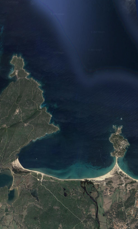
SANTA TERESA AREA - Santa Reparata
×

SANTA TERESA AREA - Santa Reparata
The beach of Santa Reparata or La Colba is located in Santa Teresa Gallura, in the extreme north-eastern tip of Sardinia. Located in a small and suggestive bay enclosed by beautiful cliffs, it is characterized by very fine light and soft sand that is reflected on clear and crystalline waters, which remain low for a long stretch from the shore. A sort of natural swimming pool with amazing colors of various shades of blue that recall distant tropical paradises.
The anchorage is perfect to visit the unique area of Capo Testa.GENERAL RESTRICTIONS:- Navigation within 200 m from the coast
- Anchoring within 200 m from the coast
- 10 knots speed limit within 1 km from the coast
- Running any craft within 200 m from the coast with engines on
- Tying lines to rocks
VIEW MAPS ON: NAVIONICS.COM - GOOGLE EARTH
ANCHORAGE NAME SANTA TERESA AREA - SANTA REPARATA COORDINATES 41°13'49.22"N 9°9'39.71"E HIGHLIGHTS CAPO TESTA SHELTERED FROM N - NE - E - SE WINDS LIMITS AND PROHIBITIONS NATURAL MARINE PARK RESTRICTIONS SEABOTTOM SAND AND ROCKS FACILITIES TO LAND ASHORE YES FACILITIES ASHORE NONE CLOSER DROP OFF POINT SANTA TERESA PORT NEAREST COASTGUARD STATION SANTA TERESA -
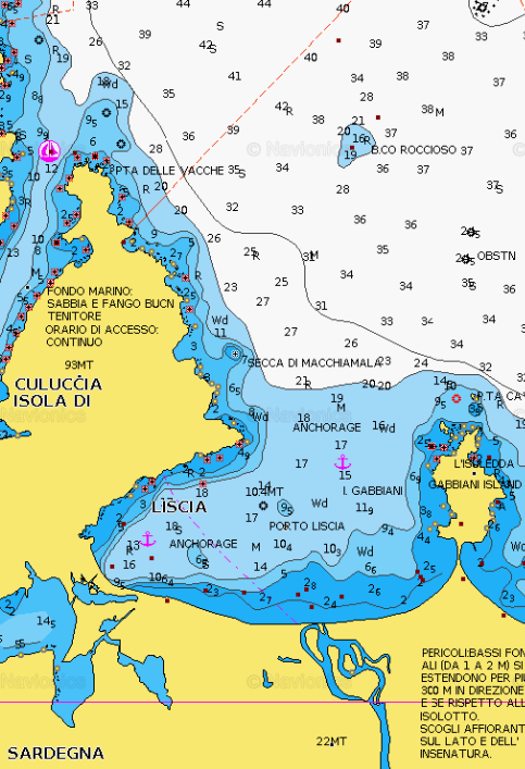
PALAU AREA - Porto Liscia
×
PALAU AREA - Porto Liscia
Porto Liscia is a wide bay off the Marine Park of La Maddalena. For this reason is ideal for watersport as there are not particular limits and restrictions. Being sourrounded by a long beach on the South side, it is a common site for windsurfers.It is open only to the Northerly winds and it is plenty of water for anchoring any size of vessel.GENERAL RESTRICTIONS:- Navigation within 200 m from the coast
- Anchoring within 200 m from the coast
- 10 knots speed limit within 1 km from the coast
- Running any craft within 200 m from the coast with engines on
- Tying lines to rocks
VIEW MAPS ON: NAVIONICS.COM - GOOGLE EARTH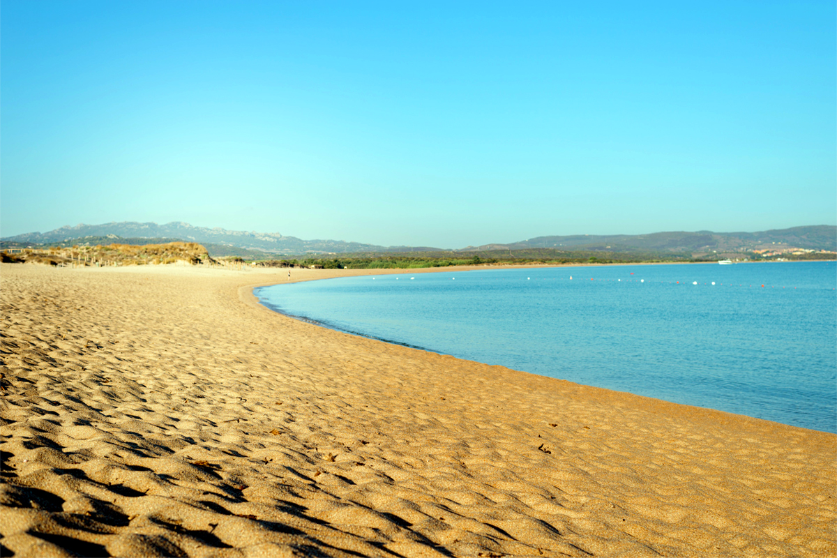
ANCHORAGE NAME PALAU AREA - PORTO LISCIA COORDINATES 41°11'52.5"N9°18'09.6"E HIGHLIGHTS WATERSPORTS SHELTERED FROM NW - W - SW - SE WINDS LIMITS AND PROHIBITIONS NO FURTHER RESTRICTIONS SEABOTTOM SAND FACILITIES TO LAND ASHORE NONE FACILITIES ASHORE YES CLOSER DROP OFF POINT PORTO LISCIA NEAREST COASTGUARD STATION PALAU -
PALAU AREA - Cala di Trana
×
PALAU AREA - Cala di Trana
Cala di Trana, is one of the most evocative beaches of Sardinia's extreme north.
It extends 200 metres in length, nestled between two enormous granite rock clusters and covered by Mediterranean scrub, can be reached only by sea.
Characterised by pink sand and a crystal-clear sea, it is very secluded, hence the lack of structured bathing facilities. It is an ideal location for those who love tranquillity and diving to explore the particular marine fauna.GENERAL RESTRICTIONS:- Navigation within 200 m from the coast
- Anchoring within 200 m from the coast
- 10 knots speed limit within 1 km from the coast
- Running any craft within 200 m from the coast with engines on
- Tying lines to rocks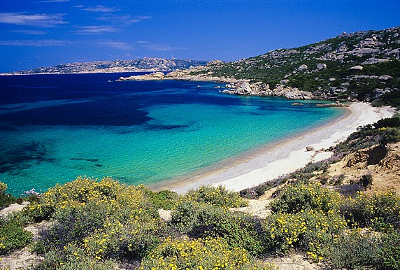
ANCHORAGE NAME CALA DI TRANA COORDINATES 41°12'21.90"N 9°21'15.77"E HIGHLIGHTS NATURAL BEAUTY, SNORKELING SHELTERED FROM W-SW-S-SE-E-NE WINDS LIMITS AND PROHIBITIONS NO FURTHER RESTRICTIONS SEABOTTOM SAND FACILITIES TO LAND ASHORE NONE FACILITIES ASHORE NONE CLOSER DROP OFF POINT PALAU NEAREST COASTGUARD STATION LA MADDALENA -
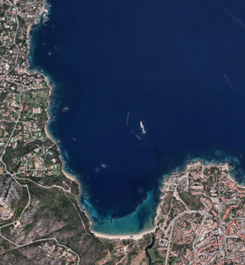
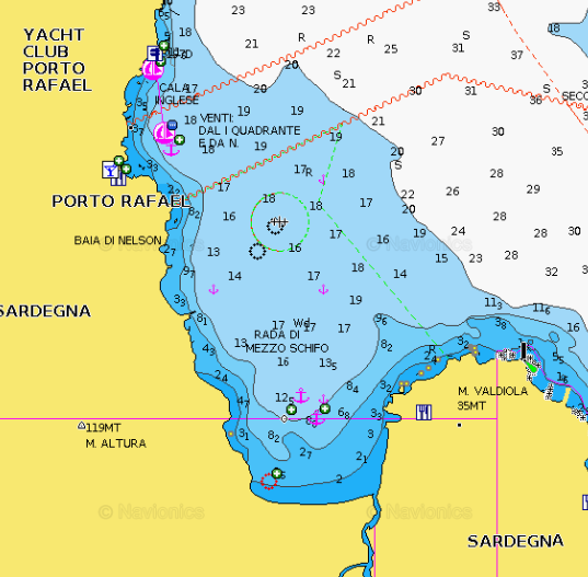
PALAU AREA - Nelson Bay or Rada di Mezzo Schifo
×
PALAU AREA - Nelson Bay or Rada di Mezzo Schifo
Sheltered from most of the prevalents winds, Nelson bay offers good holding in 16- 18m of water. Officially called Rada di Mezzo Schifo, the bay is also known as Nelson Bay.GENERAL RESTRICTIONS:- Navigation within 200 m from the coast
- Anchoring within 200 m from the coast
- 10 knots speed limit within 1 km from the coast
- Running any craft within 200 m from the coast with engines on
- Tying lines to rocks
VIEW MAPS ON: NAVIONICS.COM - GOOGLE EARTH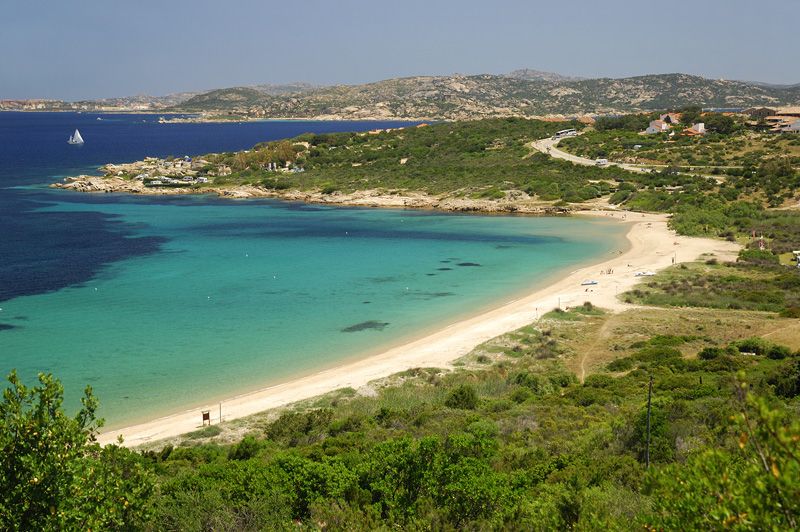
ANCHORAGE NAME PALAU AREA - NELSON BAY OR RADA DI MEZZO SCHIFO COORDINATES 41°11.0398N9°22.3235E HIGHLIGHTS LA MADDALENA NATURAL PARK SHELTERED FROM NW - W - SW - SE WINDS LIMITS AND PROHIBITIONS NO FURTHER RESTRICTION SEABOTTOM SAND FACILITIES TO LAND ASHORE NONE FACILITIES ASHORE NONE CLOSER DROP OFF POINT PORTO RAFAEL MARINA NEAREST COASTGUARD STATION PALAU -
PALAU AREA - Cala Capra
×
PALAU AREA - Cala Capra
Cala Capra is on the eastern side of Capo d'Orso, 4 km outside Palau. There is a beautiful grove of eucalyptus trees that provide shade to what has become the beach of the hotel Capo d'Orso.Protected from the mistral, the sand is medium-fine and pale yellow.A pier, where the hotel's shuttle and some other boats dock, closes off the bay and protects it from the waves when the Sirocco wind blows.The seabed provides interesting snorkeling, especially outside of the shelter of the bay, where the bottom drops to 10 metres.The hotel offers a restaurant and a wellness centre, 9 holes golf court.The little marina can accomodate boats up to 60m at the extrnal dock and up to 80 m in the 2 buoys.GENERAL RESTRICTIONS:- Navigation within 200 m from the coast
- Anchoring within 200 m from the coast
- 10 knots speed limit within 1 km from the coast
- Running any craft within 200 m from the coast with engines on
- Tying lines to rocks
VIEW MAPS ON: NAVIONICS.COM - GOOGLE EARTH
ANCHORAGE NAME PALAU AREA - CALA CAPRA COORDINATES 41°10'06.4"N9°25'16.9"E HIGHLIGHTS NATURAL BEAUTY SHELTERED FROM W - NW - SW LIMITS AND PROHIBITIONS NO FURTHER RESTRICTIONS SEABOTTOM SAND FACILITIES TO LAND ASHORE YES FACILITIES ASHORE YES CLOSER DROP OFF POINT CALA CAPRA DOCK, PALAU NEAREST COASTGUARD STATION PALAU -
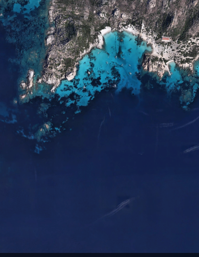
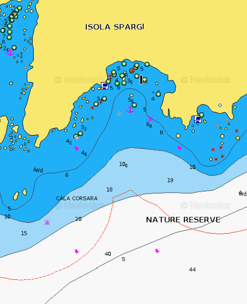
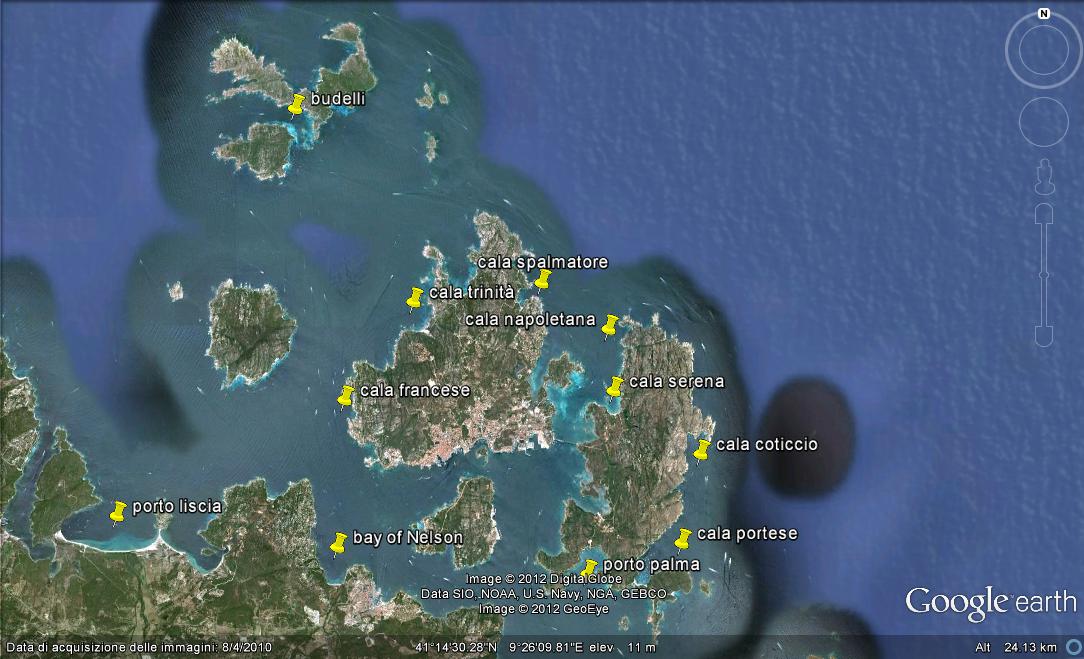
LA MADDALENA AREA - Cala Corsara (Spargi Island)
×
LA MADDALENA AREA - Cala Corsara (Spargi Island)
One among the most beautiful anchorages of Sardinia, Cala Corsara is situated in the Southern part of Spargi Island and in front one of the most picturesque beaches of La Maddalena Archipelago, famous for its white sand and crystal-blue sea. On the western side of the cove raises the well-known granite rock of Testa della Strega, shaped by sea and wind over the years. The cove is well sheltered from west and North-West winds.
PARK RESTRICTIONS:
- PARK PERMIT REQUIRED FOR NAVIGATION IN THE PARK AREA
- SEE THE ZONING MAP OF LA MADDALENA NATURAL PARKGENERAL RESTRICTIONS:Boats entering the area must observe:
- Maximum speed of 15 knots beyond 300 metres from the shore
- Maximum speed of 7 knots within 300 metres from the shore
- Anchoring: (exclusively on sandy-pebbly bottoms and never on posidonia meadows):
- from June 1 to October 30, in the zoning areas called MB the anchorage (must be outside the buoy field boundary) is allowed only from sunrise to sunset and no later than 10 pm, with the exception of La Maddalena residents and boats with crates sewage collection that can remain afterhours
- Budelli Cala di Roto Island or “Spiaggia Rosa”: The transiting, anchoring, stopping of any boat or craft is prohibited in the area of Cala di Roto or “Spiaggia Rosa”. Also prohibited are bathing, snorkeling, diving and walking on the shore. Transit near the limits of the area must be kept below 3 knots.
VIEW MAPS ON: NAVIONICS.COM - GOOGLE EARTH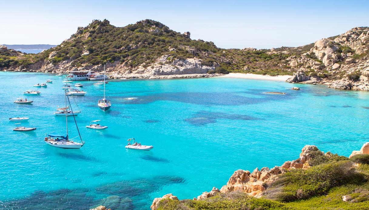
ANCHORAGE NAME CALA CORSARA (SPARGI ISLAND) COORDINATES 41°13'48.0"N9°20'36.0"E HIGHLIGHTS NATURAL BEAUTY SHELTERED FROM NW - N WINDS LIMITS AND PROHIBITIONS NATURAL MARINE PARK RESTRICTIONS SEABOTTOM SAND FACILITIES TO LAND ASHORE NONE FACILITIES ASHORE NONE CLOSER DROP OFF POINT CALA GAVETTA PORT LA MADDALENA NEAREST COASTGUARD STATION LA MADDALENA -
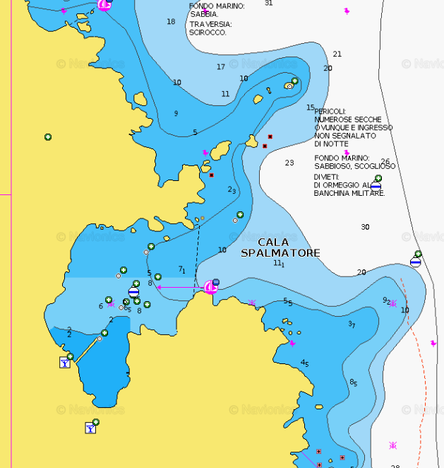
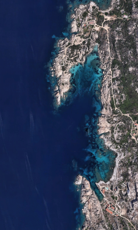
LA MADDALENA AREA - Cala Spalmatore (La Maddalena Island)
×
LA MADDALENA AREA - Cala Spalmatore (La Maddalena Island)
Cala Spalmatore is a marvellous inlet, a natural harbour located in the Northern part of the island of La Maddalena. The place is exceptional as it is quite sheltered from westerly winds and offers different services, such as those of bar, restaurant, pier, beach equipped to welcome people with disabilities on the main beach of Spalmatore. It is characterized by a white and thin sand and a crystalline turquoise sea.It offers 40 moorings at the quay or at the buoy field for boats from 12 to 55 meters.BERTHS: 20 berths at the dock, LOA up to 18m, draft up to 4m
BUOYS: 20 buoys with LOA up to 55m, draft from 5 to 9mIt is possible to freely anchor 300m from the coast, good holding. There is a pontoon to the W, with 4m depth at the end.
PARK RESTRICTIONS:
- PARK PERMIT REQUIRED FOR NAVIGATION IN THE PARK AREA
- SEE THE ZONING MAP OF LA MADDALENA NATURAL PARKGENERAL RESTRICTIONS:Boats entering the area must observe:
- Maximum speed of 15 knots beyond 300 metres from the shore
- Maximum speed of 7 knots within 300 metres from the shore
- Anchoring: (exclusively on sandy-pebbly bottoms and never on posidonia meadows):
- from June 1 to October 30, in the zoning areas called MB the anchorage (must be outside the buoy field boundary) is allowed only from sunrise to sunset and no later than 10 pm, with the exception of La Maddalena residents and boats with crates sewage collection that can remain afterhours
- Budelli Cala di Roto Island or “Spiaggia Rosa”: The transiting, anchoring, stopping of any boat or craft is prohibited in the area of Cala di Roto or “Spiaggia Rosa”. Also prohibited are bathing, snorkeling, diving and walking on the shore. Transit near the limits of the area must be kept below 3 knots.
VIEW MAPS ON: NAVIONICS.COM - GOOGLE EARTH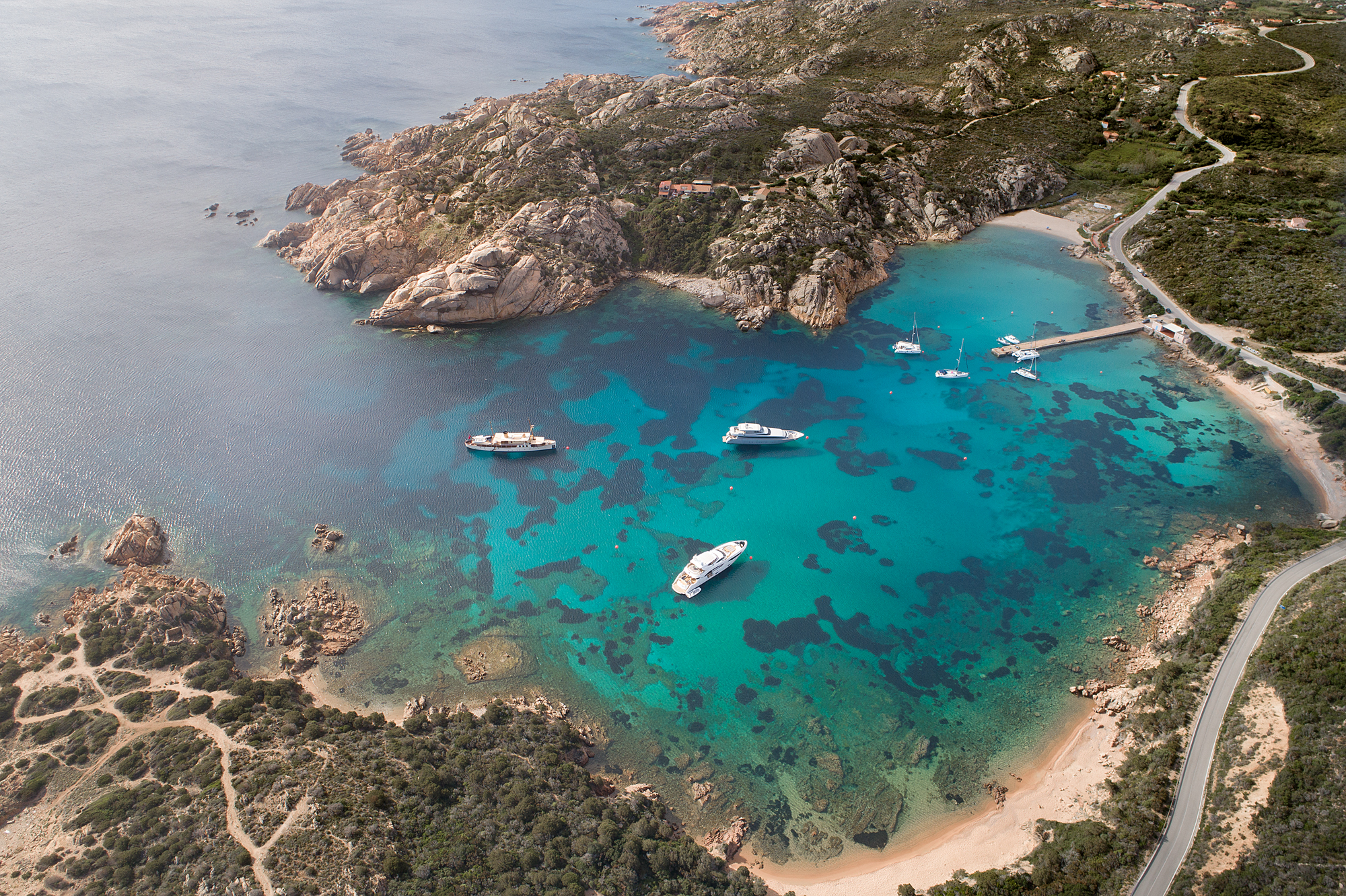
ANCHORAGE NAME CALA SPALMATORE (LA MADDALENA ISLAND) COORDINATES 41°14'58.546"N9°25'46.610"E HIGHLIGHTS NATURAL BEAUTY SHELTERED FROM NW - W - SW WIND LIMITS AND PROHIBITIONS NATURAL MARINE PARK RESTRICTIONS SEABOTTOM SAND, ROCKS FACILITIES TO LAND ASHORE YES FACILITIES ASHORE YES CLOSER DROP OFF POINT PORTO MASSIMO NEAREST COASTGUARD STATION LA MADDALENA -
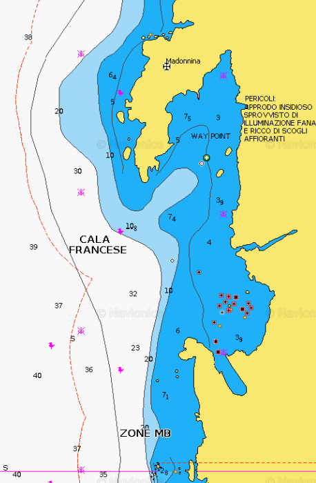
LA MADDALENA AREA - Cala Francese (La Maddalena Island)
×
LA MADDALENA AREA - Cala Francese (La Maddalena Island)
PARK RESTRICTIONS:- PARK PERMIT REQUIRED FOR NAVIGATION IN THE PARK AREA
- SEE THE ZONING MAP OF LA MADDALENA NATURAL PARKGENERAL RESTRICTIONS:Boats entering the area must observe:
- Maximum speed of 15 knots beyond 300 metres from the shore
- Maximum speed of 7 knots within 300 metres from the shore
- Anchoring: (exclusively on sandy-pebbly bottoms and never on posidonia meadows):
- from June 1 to October 30, in the zoning areas called MB the anchorage (must be outside the buoy field boundary) is allowed only from sunrise to sunset and no later than 10 pm, with the exception of La Maddalena residents and boats with crates sewage collection that can remain afterhours
- Budelli Cala di Roto Island or “Spiaggia Rosa”: The transiting, anchoring, stopping of any boat or craft is prohibited in the area of Cala di Roto or “Spiaggia Rosa”. Also prohibited are bathing, snorkeling, diving and walking on the shore. Transit near the limits of the area must be kept below 3 knots.
VIEW MAPS ON: NAVIONICS.COM - GOOGLE EARTH
ANCHORAGE NAME CALA FRANCESE (LA MADDALENA ISLAND) COORDINATES 41°13'34.165"N9°22'34.766"E HIGHLIGHTS NATURAL BEAUTY SHELTERED FROM NE - E - SE WINDS LIMITS AND PROHIBITIONS NATURAL MARINE PARK RESTRICTIONS SEABOTTOM SAND, ROCKS FACILITIES TO LAND ASHORE NONE FACILITIES ASHORE YES CLOSER DROP OFF POINT CALA GAVETTA PORT LA MADDALENA NEAREST COASTGUARD STATION LA MADDALENA -
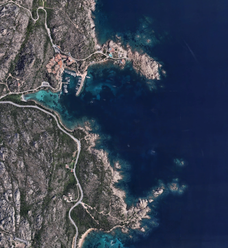
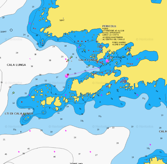
LA MADDALENA AREA - Cala Lunga – Porto Massimo (La Maddalena Island)
×
LA MADDALENA AREA - Cala Lunga – Porto Massimo (La Maddalena Island)
Porto Massimo and its beautiful bay Cala Lunga are located in the northern part of Maddalena island. This anchorage has become a very popular meeting place for the international jet set during summer time. This amazing bay and its beach beside being incredibly beautiful have become famous also thanks to the great service and hospitality given by La Scogliera Restaurant. Famous for their seafood specialties, a lunch in La Scogliera or a romantic dinner sea view has become a must for yacht clients. The little but very well organized port of Porto Massimo is a very useful spot for guests drop off and guests pick up, and very useful for any need during your cruise in this area. The beach right at the end of the bay is white and soft sand while the water is incredibly transparent with amazing blue and turquoise nuances.The port can accomodates boats up to 50m between berths and buoys.BERTHS (140): up to LOA 32m on internal dock, max draft 3,8m; up to 42m on the external dock.BUOYS (10):- external dock 4 shore buoys, LOA up to 42m and draft up to 2,85m
- bay front of the port: 2 buoys up to LOA 50m, 8 buoys up to LOA 15-20m
PARK RESTRICTIONS:
- PARK PERMIT REQUIRED FOR NAVIGATION IN THE PARK AREA
- SEE THE ZONING MAP OF LA MADDALENA NATURAL PARKGENERAL RESTRICTIONS:Boats entering the area must observe:
- Maximum speed of 15 knots beyond 300 metres from the shore
- Maximum speed of 7 knots within 300 metres from the shore
- Anchoring: (exclusively on sandy-pebbly bottoms and never on posidonia meadows):
- from June 1 to October 30, in the zoning areas called MB the anchorage (must be outside the buoy field boundary) is allowed only from sunrise to sunset and no later than 10 pm, with the exception of La Maddalena residents and boats with crates sewage collection that can remain afterhours
- Budelli Cala di Roto Island or “Spiaggia Rosa”: The transiting, anchoring, stopping of any boat or craft is prohibited in the area of Cala di Roto or “Spiaggia Rosa”. Also prohibited are bathing, snorkeling, diving and walking on the shore. Transit near the limits of the area must be kept below 3 knots.
VIEW MAPS ON: NAVIONICS.COM - GOOGLE EARTH
ANCHORAGE NAME LA MADDALENA AREA - CALA LUNGA – PORTO MASSIMO COORDINATES 41°15'28.8"N9°25'50.4"E HIGHLIGHTS NATURAL BEAUTY, RESTAURANT LA SCOGLIERA SHELTERED FROM N-NW-W-SW-S WINDS LIMITS AND PROHIBITIONS NATURAL MARINE PARK RESTRICTIONS SEABOTTOM SAND FACILITIES TO LAND ASHORE YES FACILITIES ASHORE YES CLOSER DROP OFF POINT PORTO MASSIMO NEAREST COASTGUARD STATION LA MADDALENA -
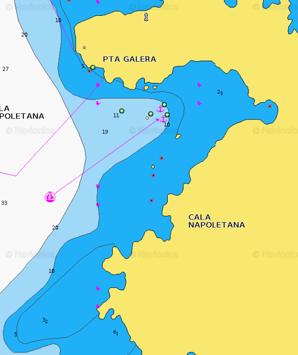
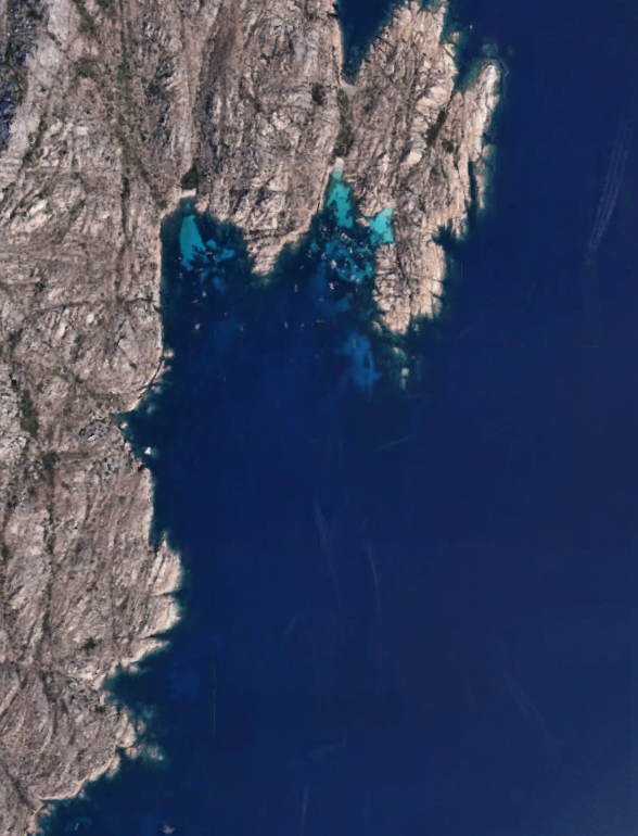
LA MADDALENA AREA - Cala Napoletana (Caprera)
×
LA MADDALENA AREA - Cala Napoletana (Caprera)
On the NW of Caprera island stands Cala Napoletana, an authentic paradise with spotless sand, limpid waters and Mediterranean shrub. An ideal place for those wishing to spend a relaxing day.
This very tiny bay it is very popular within yachts and reachable by tender when anchoring in between La Maddalena and Caprera island.PARK RESTRICTIONS:
- PARK PERMIT REQUIRED FOR NAVIGATION IN THE PARK AREA
- SEE THE ZONING MAP OF LA MADDALENA NATURAL PARKGENERAL RESTRICTIONS:
Boats entering the area must observe:
- Maximum speed of 15 knots beyond 300 metres from the shore
- Maximum speed of 7 knots within 300 metres from the shore
- Anchoring: (exclusively on sandy-pebbly bottoms and never on posidonia meadows):
- from June 1 to October 30, in the zoning areas called MB the anchorage (must be outside the buoy field boundary) is allowed only from sunrise to sunset and no later than 10 pm, with the exception of La Maddalena residents and boats with crates sewage collection that can remain afterhours
- Budelli Cala di Roto Island or “Spiaggia Rosa”: The transiting, anchoring, stopping of any boat or craft is prohibited in the area of Cala di Roto or “Spiaggia Rosa”. Also prohibited are bathing, snorkeling, diving and walking on the shore. Transit near the limits of the area must be kept below 3 knots.
VIEW MAPS ON: NAVIONICS.COM - GOOGLE EARTH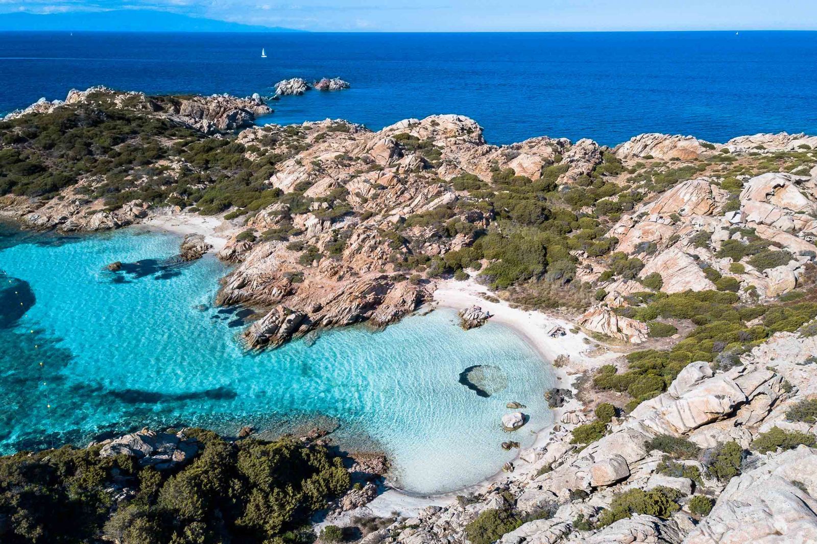
ANCHORAGE NAME LA MADDALENA AREA - CALA NAPOLETANA (CAPRERA) COORDINATES 41°14'32.1"N9°27'41.8"E HIGHLIGHTS NATURAL BEAUTY SHELTERED FROM W-SW-SE-E WINDS LIMITS AND PROHIBITIONS NATURAL MARINE PARK RESTRICTIONS SEABOTTOM SAND FACILITIES TO LAND ASHORE NONE FACILITIES ASHORE NONE CLOSER DROP OFF POINT PORTO MASSIMO NEAREST COASTGUARD STATION LA MADDALENA -
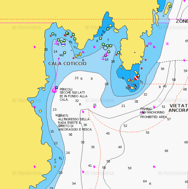
LA MADDALENA AREA - Cala Coticcio (Caprera)
×
LA MADDALENA AREA - Cala Coticcio (Caprera)
A beach with a nickname as Tahiti doesn’t leave too many doubts about its impressive beauty!
Cala Coticcio beach is a jem in the west side of Caprera island, in the Maddalena Archipelago national park. In a stunning landscape you will find yourself in a real natural pool reachable only by boat. An authentic aquarium with numerous species of fish and starfish. It is ideal for snorkelling enthusiasts. The island of Caprera is famous also for the fact that Giuseppe Garibaldi lived there until his death in 1882. His house is nowadays a visitable romantic museum.The anchorage is allowed on sandy bottom at 300 meters from the shore. Cala Coticcio is one of the most popular anchorages in the North of sardinia, so it can get quite busy during the summer.
PARK RESTRICTIONS:
- PARK PERMIT REQUIRED FOR NAVIGATION IN THE PARK AREA
- SEE THE ZONING MAP OF LA MADDALENA NATURAL PARKGENERAL RESTRICTIONS:
Boats entering the area must observe:
- Maximum speed of 15 knots beyond 300 metres from the shore
- Maximum speed of 7 knots within 300 metres from the shore
- Anchoring: (exclusively on sandy-pebbly bottoms and never on posidonia meadows):
- from June 1 to October 30, in the zoning areas called MB the anchorage (must be outside the buoy field boundary) is allowed only from sunrise to sunset and no later than 10 pm, with the exception of La Maddalena residents and boats with crates sewage collection that can remain afterhours
- Budelli Cala di Roto Island or “Spiaggia Rosa”: The transiting, anchoring, stopping of any boat or craft is prohibited in the area of Cala di Roto or “Spiaggia Rosa”. Also prohibited are bathing, snorkeling, diving and walking on the shore. Transit near the limits of the area must be kept below 3 knots.
VIEW MAPS ON: NAVIONICS.COM - GOOGLE EARTH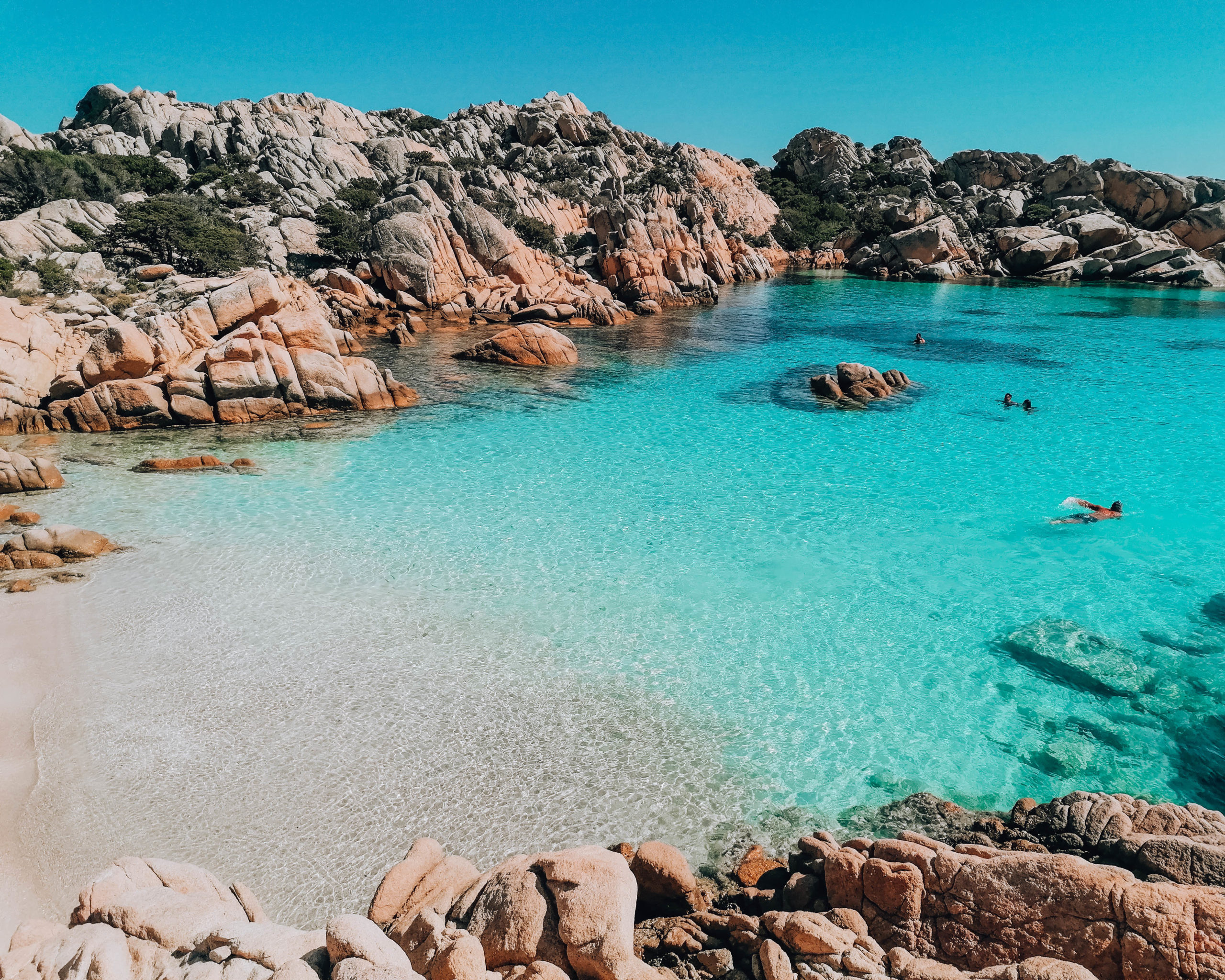
ANCHORAGE NAME CALA COTICCIO (CAPRERA) COORDINATES 41° 13' 1.722" N 9° 29' 4.636" E HIGHLIGHTS NATURAL BEAUTY SHELTERED FROM SW-W-NW WINDS LIMITS AND PROHIBITIONS NATURAL MARINE PARK RESTRICTIONS SEABOTTOM SAND, SEAWEED FACILITIES TO LAND ASHORE NO FACILITIES ASHORE NO FACILITIES ON THE SHORE CLOSER DROP OFF POINT POLTU QUATU NEAREST COASTGUARD STATION LA MADDALENA -
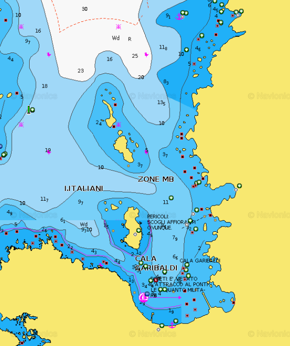
LA MADDALENA AREA - Cala Garibaldi (Caprera)
×
LA MADDALENA AREA - Cala Garibaldi (Caprera)
Cala Garibaldi, a stunning cove nestled in the Maddalena archipelago of Sardinia's northeast, boasts picturesque sandy shores and clear waters. Named after Giuseppe Garibaldi, it offers a glimpse into history with remnants of his harbor. With its fine golden sands and crystalline waters, it's a favorite among families. The beach is ideal for snorkeling, fishing, and windsurfing, framed by verdant Mediterranean foliage and contrasting with the vibrant sea. Further north lie two small bays, Cala Serena, sheltered by pink rocks.
PARK RESTRICTIONS:
- PARK PERMIT REQUIRED FOR NAVIGATION IN THE PARK AREA
- SEE THE ZONING MAP OF LA MADDALENA NATURAL PARKGENERAL RESTRICTIONS:Boats entering the area must observe:
- Maximum speed of 15 knots beyond 300 metres from the shore
- Maximum speed of 7 knots within 300 metres from the shore
- Anchoring: (exclusively on sandy-pebbly bottoms and never on posidonia meadows):
- from June 1 to October 30, in the zoning areas called MB the anchorage (must be outside the buoy field boundary) is allowed only from sunrise to sunset and no later than 10 pm, with the exception of La Maddalena residents and boats with crates sewage collection that can remain afterhours
- Budelli Cala di Roto Island or “Spiaggia Rosa”: The transiting, anchoring, stopping of any boat or craft is prohibited in the area of Cala di Roto or “Spiaggia Rosa”. Also prohibited are bathing, snorkeling, diving and walking on the shore. Transit near the limits of the area must be kept below 3 knots.
VIEW MAPS ON: NAVIONICS.COM - GOOGLE EARTH
ANCHORAGE NAME LA MADDALENA ISLAND - CALA GARIBALDI (CAPRERA) COORDINATES 41°13'29.845"N9°27'27.612"E HIGHLIGHTS NATURAL BEAUTY SHELTERED FROM W-SW-S-SE-E WINDS LIMITS AND PROHIBITIONS NATURAL MARINE PARK RESTRICTIONS SEABOTTOM SAND AND ROCKS FACILITIES TO LAND ASHORE NONE FACILITIES ASHORE NONE CLOSER DROP OFF POINT PORTO MASSIMO OR CALA GAVETTA PORT LA MADDALENA NEAREST COASTGUARD STATION LA MADDALENA -
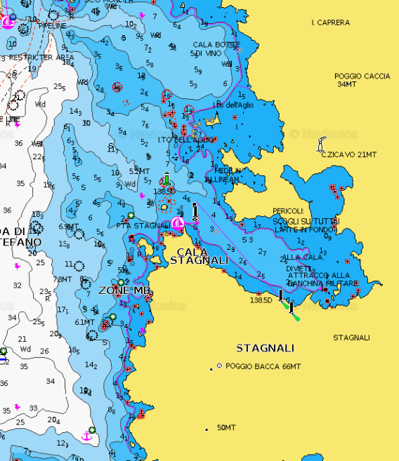
LA MADDALENA AREA - Cala Stagnali (Caprera)
×
LA MADDALENA AREA - Cala Stagnali (Caprera)
The port of Cala Stagnali is located on the west coast of the island of Caprera. A masonry pier has been built in a large inlet to which small boats can dock. Access to the cove is continuous and in the entrance you must follow the alignment with the green light, paying attention to the rocks on all sides and at the bottom of the cove.PARK RESTRICTIONS:
- PARK PERMIT REQUIRED FOR NAVIGATION IN THE PARK AREA
- SEE THE ZONING MAP OF LA MADDALENA NATURAL PARKGENERAL RESTRICTIONS:Boats entering the area must observe:
- Maximum speed of 15 knots beyond 300 metres from the shore
- Maximum speed of 7 knots within 300 metres from the shore
- Anchoring: (exclusively on sandy-pebbly bottoms and never on posidonia meadows):
- from June 1 to October 30, in the zoning areas called MB the anchorage (must be outside the buoy field boundary) is allowed only from sunrise to sunset and no later than 10 pm, with the exception of La Maddalena residents and boats with crates sewage collection that can remain afterhours
- Budelli Cala di Roto Island or “Spiaggia Rosa”: The transiting, anchoring, stopping of any boat or craft is prohibited in the area of Cala di Roto or “Spiaggia Rosa”. Also prohibited are bathing, snorkeling, diving and walking on the shore. Transit near the limits of the area must be kept below 3 knots.
VIEW MAPS ON: NAVIONICS.COM - GOOGLE EARTH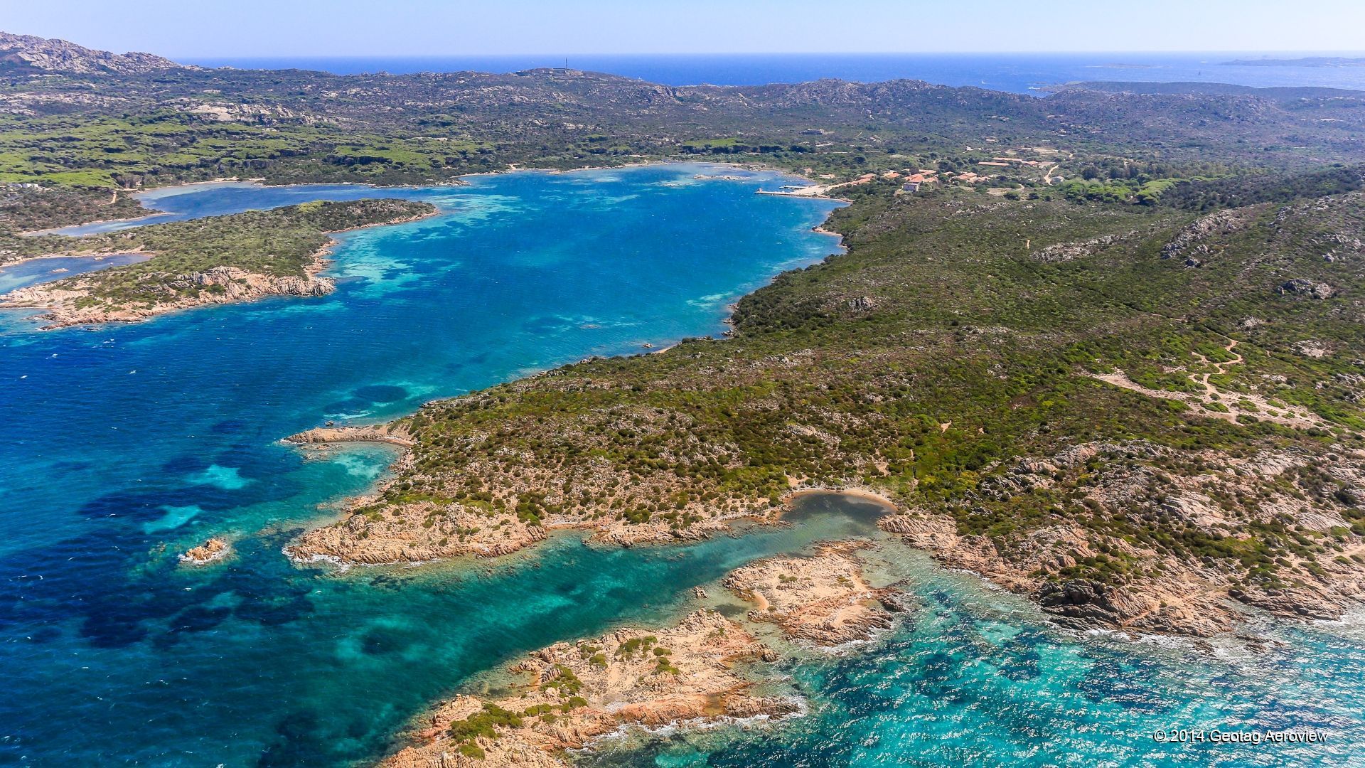
ANCHORAGE NAME LA MADDALENA AREA - CALA STAGNALI (CAPRERA) COORDINATES 41°11'18.9"N9°27'02.1"E HIGHLIGHTS NATURAL BEAUTY SHELTERED FROM N - NE - E WINDS LIMITS AND PROHIBITIONS NATURAL MARINE PARK RESTRICTIONS SEABOTTOM SAND AND ROCKS FACILITIES TO LAND ASHORE YES FACILITIES ASHORE NONE CLOSER DROP OFF POINT CALA CAPRA NEAREST COASTGUARD STATION LA MADDALENA -
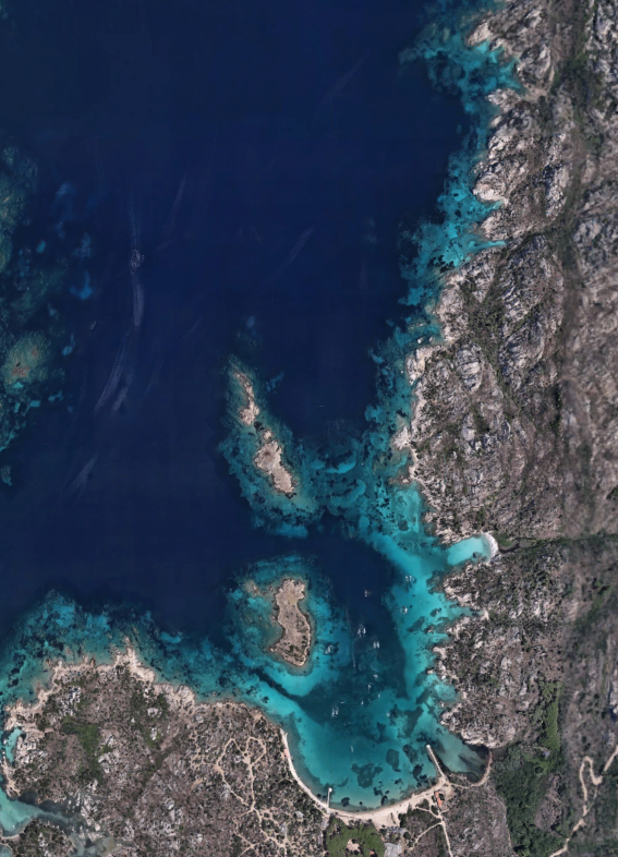
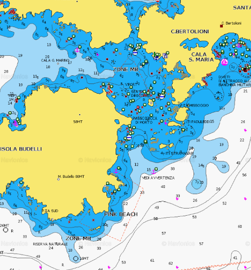
LA MADDALENA AREA - Cala Santa Maria (Santa Maria Island)
×
LA MADDALENA AREA - Cala Santa Maria (Santa Maria Island)
Santa Maria, together with the other two beautiful islets of Razzoli and Budelli, represents the northernmost part of the Maddalena archipelago park, one of the unmissable destinations in your excursion among the approximately 60 islands that compose it. The islet has an area of two square kilometers, while the perimeter of its rugged coastline measures ten kilometers. The characteristic that distinguishes it from the other smaller Maddalena islands is that of being the only one permanently inhabited, obviously beyond its older 'sister' La Maddalena.Santa Maria bay is composed of fine white sand, bathed by the pristine sea, rich in marine fauna. 200 meters long, it is the largest beach in the entire archipelago.
Its shallow and sandy bottom sloping towards the open sea forms a splendid natural pool.
The cove is surrounded by pink-toned rocks covered in Mediterranean green. Behind the bay extends a lake of brackish water, the Marsh, habitat of numerous species of water birds: woodcocks, hen, mallards.
The famous Restaurant La Casitta is on the island.PARK RESTRICTIONS:
- PARK PERMIT REQUIRED FOR NAVIGATION IN THE PARK AREA
- SEE THE ZONING MAP OF LA MADDALENA NATURAL PARKGENERAL RESTRICTIONS:Boats entering the area must observe:
- Maximum speed of 15 knots beyond 300 metres from the shore
- Maximum speed of 7 knots within 300 metres from the shore
- Anchoring: (exclusively on sandy-pebbly bottoms and never on posidonia meadows):
- from June 1 to October 30, in the zoning areas called MB the anchorage (must be outside the buoy field boundary) is allowed only from sunrise to sunset and no later than 10 pm, with the exception of La Maddalena residents and boats with crates sewage collection that can remain afterhours
- Budelli Cala di Roto Island or “Spiaggia Rosa”: The transiting, anchoring, stopping of any boat or craft is prohibited in the area of Cala di Roto or “Spiaggia Rosa”. Also prohibited are bathing, snorkeling, diving and walking on the shore. Transit near the limits of the area must be kept below 3 knots.
VIEW MAPS ON: NAVIONICS.COM - GOOGLE EARTH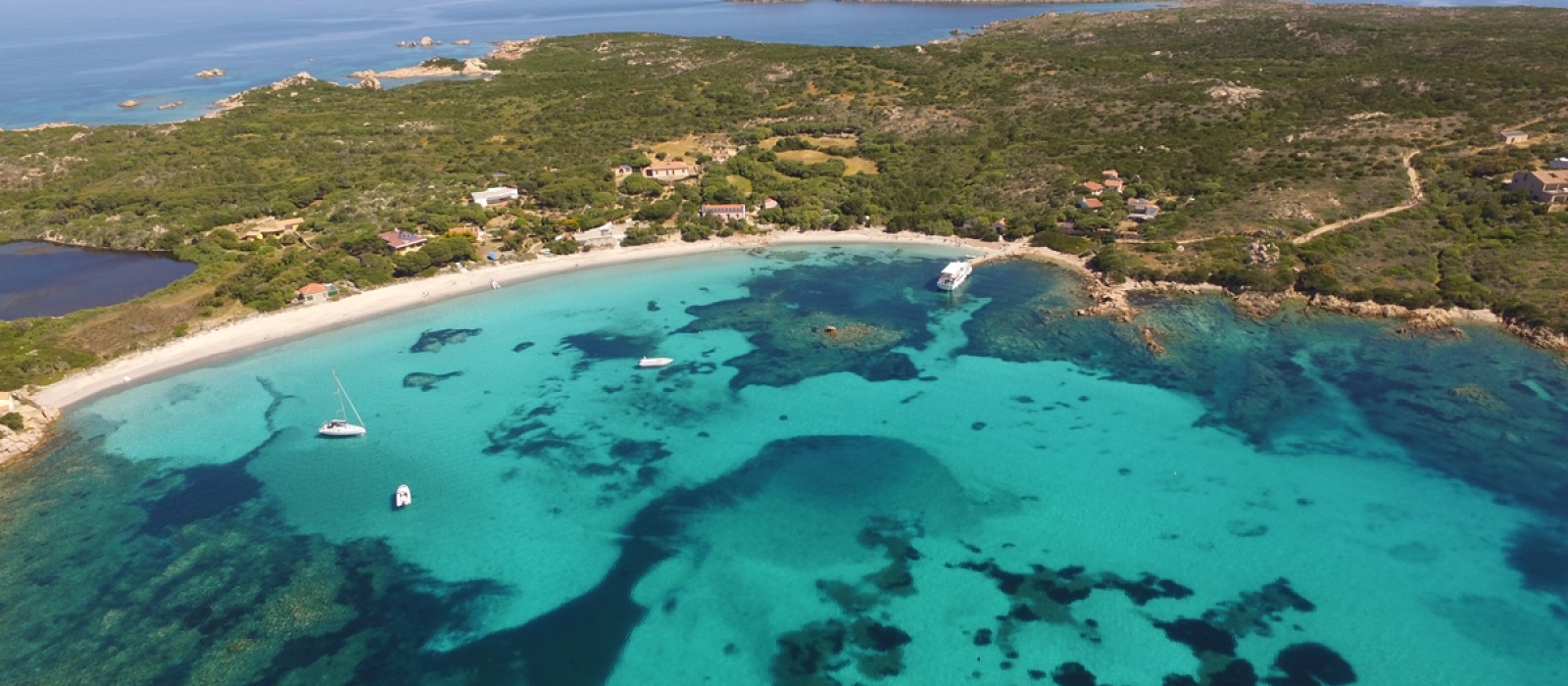
ANCHORAGE NAME LA MADDALENA AREA - CALA SANTA MARIA (SANTA MARIA ISLAND) COORDINATES 41°17'37.453"N9°22'19.240"E HIGHLIGHTS NATURAL BEAUTY SHELTERED FROM NW WINDS LIMITS AND PROHIBITIONS NATURAL MARINE PARK RESTRICTIONS SEABOTTOM SAND FACILITIES TO LAND ASHORE NONE FACILITIES ASHORE NONE CLOSER DROP OFF POINT PALAU NEAREST COASTGUARD STATION LA MADDALENA -
LA MADDALENA AREA - Cala Lunga (Razzoli Island)
×
LA MADDALENA AREA - Cala Lunga (Razzoli Island)
Cala Lunga bay is located in an inlet in the southern part of the island of Razzoli and its beach is characterized by a very white and thin sand and a limpid and crystalline sea.
The landscape surrounding the beach is mainly made up of granite rocks and Mediterranean scrub. The beach can be reached only by sea.
Beware of rocks outcropping at the port entrance. Remain at the center of the passage. The depth is 2 to 4 m.PARK RESTRICTIONS:
- PARK PERMIT REQUIRED FOR NAVIGATION IN THE PARK AREA
- SEE THE ZONING MAP OF LA MADDALENA NATURAL PARKGENERAL RESTRICTIONS:Boats entering the area must observe:
- Maximum speed of 15 knots beyond 300 metres from the shore
- Maximum speed of 7 knots within 300 metres from the shore
- Anchoring: (exclusively on sandy-pebbly bottoms and never on posidonia meadows):
- from June 1 to October 30, in the zoning areas called MB the anchorage (must be outside the buoy field boundary) is allowed only from sunrise to sunset and no later than 10 pm, with the exception of La Maddalena residents and boats with crates sewage collection that can remain afterhours
- Budelli Cala di Roto Island or “Spiaggia Rosa”: The transiting, anchoring, stopping of any boat or craft is prohibited in the area of Cala di Roto or “Spiaggia Rosa”. Also prohibited are bathing, snorkeling, diving and walking on the shore. Transit near the limits of the area must be kept below 3 knots.
VIEW MAPS ON: NAVIONICS.COM - GOOGLE EARTH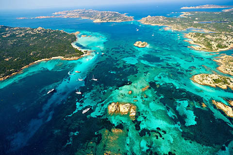
ANCHORAGE NAME CALA LUNGA (RAZZOLI ISLAND) COORDINATES 41°17'59''N9°20'39''E HIGHLIGHTS LA CASITTA RESTAURANT IN SANTA MARIA ISLAND SHELTERED FROM S - SE - E LIMITS AND PROHIBITIONS NATURAL MARINE PARK RESTRICTIONS SEABOTTOM SAND FACILITIES TO LAND ASHORE NONE FACILITIES ASHORE NONE CLOSER DROP OFF POINT PALAU NEAREST COASTGUARD STATION LA MADDALENA -
LA MADDALENA AREA - Porto della Madonna (Budelli Island)
×
LA MADDALENA AREA - Porto della Madonna (Budelli Island)
Known as well as ‘’Manto della Madonna’’ (Virgin’s mantle), an amazing natural reflecting pool of an almost impossible blue located on the Eastern part of Budelli Island, in front of the wonderful bays of Santa Maria and Razzoli Islands. The name comes from the incredibly transparent and intense blue waters of this sea stretch: one of the most enchanting places in La Maddalena Archipelago.It is a marvellous cove of light, impalpable sand, embraced by golden and pink rocks covered by the scented Mediterranean scrub.
Behind the beach there is a pond populated by little egrets, herons, coots and mallard ducks.
A lunch in La Casitta restaurant will complete with an absolute luxury experience.PARK RESTRICTIONS:
- PARK PERMIT REQUIRED FOR NAVIGATION IN THE PARK AREA
- SEE THE ZONING MAP OF LA MADDALENA NATURAL PARK
GENERAL RESTRICTIONS:
Boats entering the area must observe:
- Maximum speed of 15 knots beyond 300 metres from the shore
- Maximum speed of 7 knots within 300 metres from the shore
- Anchoring: (exclusively on sandy-pebbly bottoms and never on posidonia meadows):
- from June 1 to October 30, in the zoning areas called MB the anchorage (must be outside the buoy field boundary) is allowed only from sunrise to sunset and no later than 10 pm, with the exception of La Maddalena residents and boats with crates sewage collection that can remain afterhours
- Budelli Cala di Roto Island or “Spiaggia Rosa”: The transiting, anchoring, stopping of any boat or craft is prohibited in the area of Cala di Roto or “Spiaggia Rosa”. Also prohibited are bathing, snorkeling, diving and walking on the shore. Transit near the limits of the area must be kept below 3 knots.
VIEW MAPS ON: NAVIONICS.COM - GOOGLE EARTH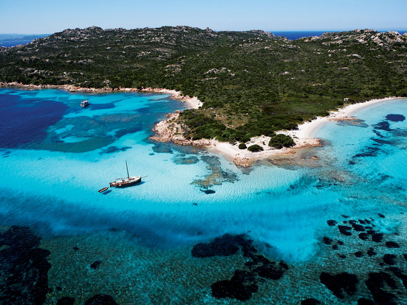
ANCHORAGE NAME PORTO DELLA MADONNA (BUDELLI - SANTA MARIA - RAZZOLI ISLANDS) COORDINATES 41°17'29.71"N 9°21'2.61"E HIGHLIGHTS NATURAL BEAUTY, LA CASITTA RESTAURANT SHELTERED FROM N - NE - S - SE WINDS LIMITS AND PROHIBITIONS NATURAL MARINE PARK RESTRICTIONS SEABOTTOM SAND, SEAWEED FACILITIES TO LAND ASHORE NONE FACILITIES ASHORE YES CLOSER DROP OFF POINT PALAU NEAREST COASTGUARD STATION LA MADDALENA