costa smeralda
from Porto Cervo to Porto Rotondo
Anchorages
Hide MapIf you want to continue the navigation, please sign up
Request your temporary Access Code
This operational platform has been created to help yacht captains, yacht brokers, crew members, yacht agents and all people involved in the yachting industry to find in our DISCOVER SARDINIA section the right operational tool for cruising Sardinia. Nautica Assistance reserves the right to accept or decline the registration. Once accepted you will be receiving an access code with a validity of six months.
-
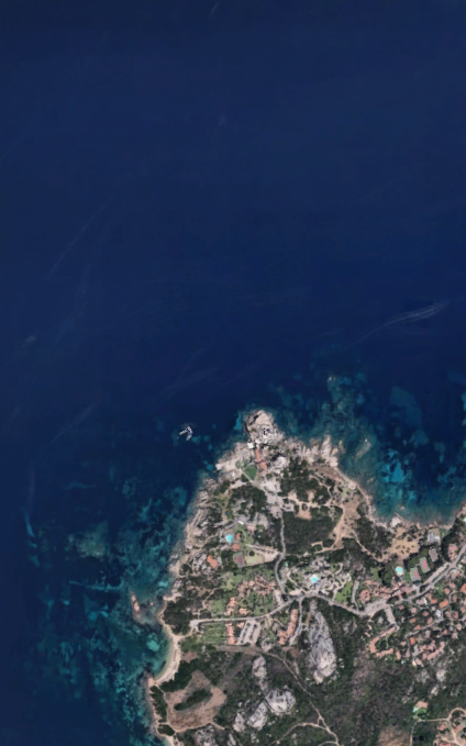
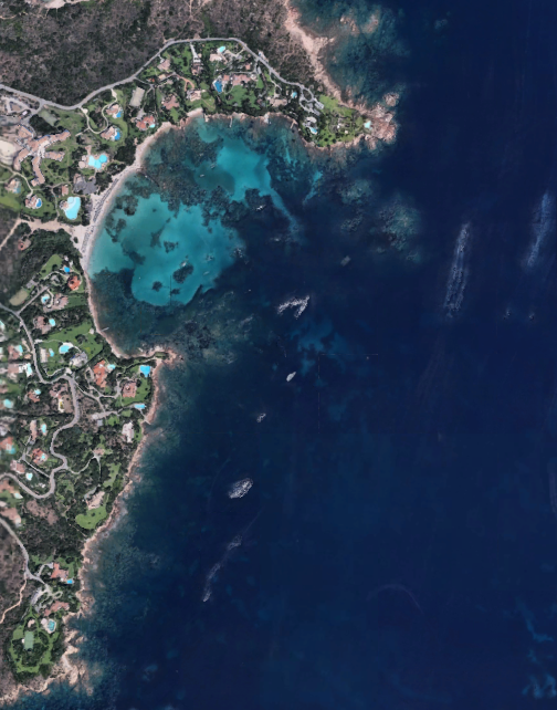
PORTO CERVO AREA - Forte Cappellini (Phi Beach)
×

PORTO CERVO AREA - Forte Cappellini (Phi Beach)
A very special anchorage, facing the South of Caprera island, in the area of Baja Sardinia, where most of our clients are happy to spend time overall during sunset and night time.
The anchorage, located right front of Phi Beach club, is perfect for a stop by at the club perhaps after enjoying the Maddalena’s park crystaline waters during the day. The spot gives a great chance to enjoy a drink or a dinner with an amazing sunset on the sea and a spectacular view on the Maddalena’s archipelago.
Phi Beach club, definitely an evocative icon of the Emerald Coast’s nightlife, is an open air club located near the military outpost of Forte Cappellini, that, in the XIX century, was an important fortress dedicated to the defense of North Sardinia. Protected by enchanting rock formations shaped by the sea, its breathtaking natural position brings the unique experience of one of the most beautiful sunsets of the island.
Sheltered from S, SE, SW winds and outside of the Marine park restrictions.GENERAL RESTRICTIONS:- Navigation within 200 m from the coast
- Anchoring within 200 m from the coast
- 10 knots speed limit within 1 km from the coast
- Running any craft within 200 m from the coast with engines on
- Tying lines to rocks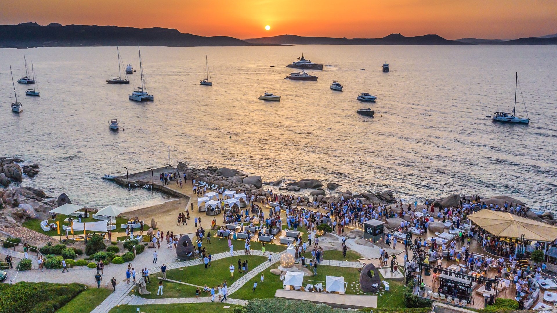
ANCHORAGE NAME PORTO CERVO AREA - FORTE CAPPELLINI (PHI BEACH) COORDINATES 41°08'33.0"N9°27'55.6"E HIGHLIGHTS PHI BEACH CLUB & RESTAURANT SHELTERED FROM S - SE - SW WINDS LIMITS AND PROHIBITIONS NO FURTHER RESTRICTIONS SEABOTTOM SAND, ROCKS FACILITIES TO LAND ASHORE YES FACILITIES ASHORE YES CLOSER DROP OFF POINT PHI BEACH DOCK FOR GUESTS NEAREST COASTGUARD STATION PALAU -
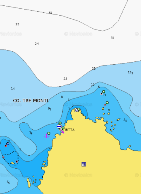
PORTO CERVO AREA - Liscia di Vacca (Pitrizza bay)
×
PORTO CERVO AREA - Liscia di Vacca (Pitrizza bay)
Beautiful anchorage facing the famous Pitrizza Hotel. The whiteness and brightness of the sand and the typical vivid colours of the Costa Smeralda sea will give you breathtaking views.
In the bay you will find a concrete dock suitable for guests and goods pick up/drop offs.
Protected from S, SW, SE winds and also NE wind deep inside you can easily spend some good time in this bay with Poltu Quatu and Porto Cervo just around the corner.GENERAL RESTRICTIONS:- Navigation within 200 m from the coast
- Anchoring within 200 m from the coast
- 10 knots speed limit within 1 km from the coast
- Running any craft within 200 m from the coast with engines on
- Tying lines to rocks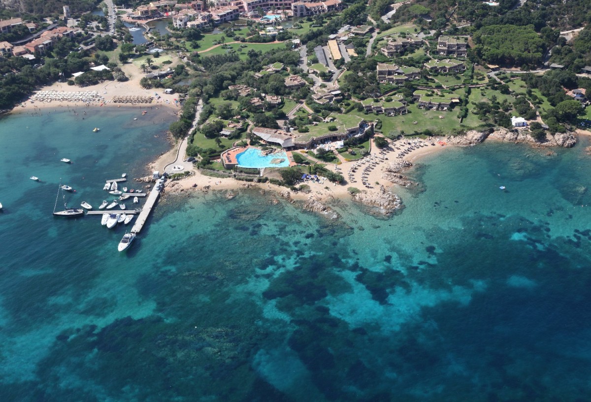
ANCHORAGE NAME PORTO CERVO AREA - LISCIA DI VACCA (PITRIZZA BAY) COORDINATES 41°08'31.9"N9°30'34.8"E HIGHLIGHTS PITRIZZA HOTEL SHELTERED FROM SW - S - SE - NE - E LIMITS AND PROHIBITIONS NO FURTHER RESTRICTIONS SEABOTTOM SAND, ROCKS FACILITIES TO LAND ASHORE YES FACILITIES ASHORE YES CLOSER DROP OFF POINT PITRIZZA CONCRETE DOCK NEAREST COASTGUARD STATION PALAU -
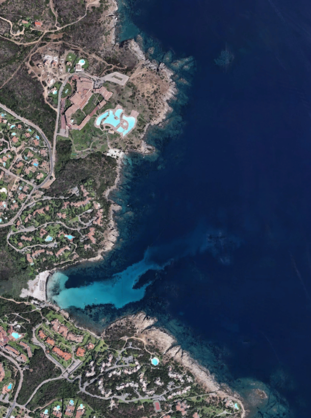
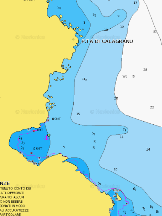
PORTO CERVO AREA - Cala Granu
×
PORTO CERVO AREA - Cala Granu
Cala Granu, a few steps from Porto Cervo, is an unforgettable water mirror with different shades of emerald green and deep blue. Cala Granu beach lies conveniently close to Porto Cervo Grand Hotel and its beach.
It is sheltered from the westerly winds. Ideal for families and for those who love tranquility.GENERAL RESTRICTIONS:- Navigation within 200 m from the coast
- Anchoring within 200 m from the coast
- 10 knots speed limit within 1 km from the coast
- Running any craft within 200 m from the coast with engines on
- Tying lines to rocks
ANCHORAGE NAME PORTO CERVO AREA - CALA GRANU COORDINATES 41°08'46.1"N9°31'44.3"E HIGHLIGHTS NATURAL BEAUTY SHELTERED FROM NW-W-SW WINDS LIMITS AND PROHIBITIONS NO FURTHER RESTRICTIONS SEABOTTOM SAND FACILITIES TO LAND ASHORE NONE FACILITIES ASHORE YES CLOSER DROP OFF POINT PORTO CERVO FUEL DOCK NEAREST COASTGUARD STATION PORTO CERVO -
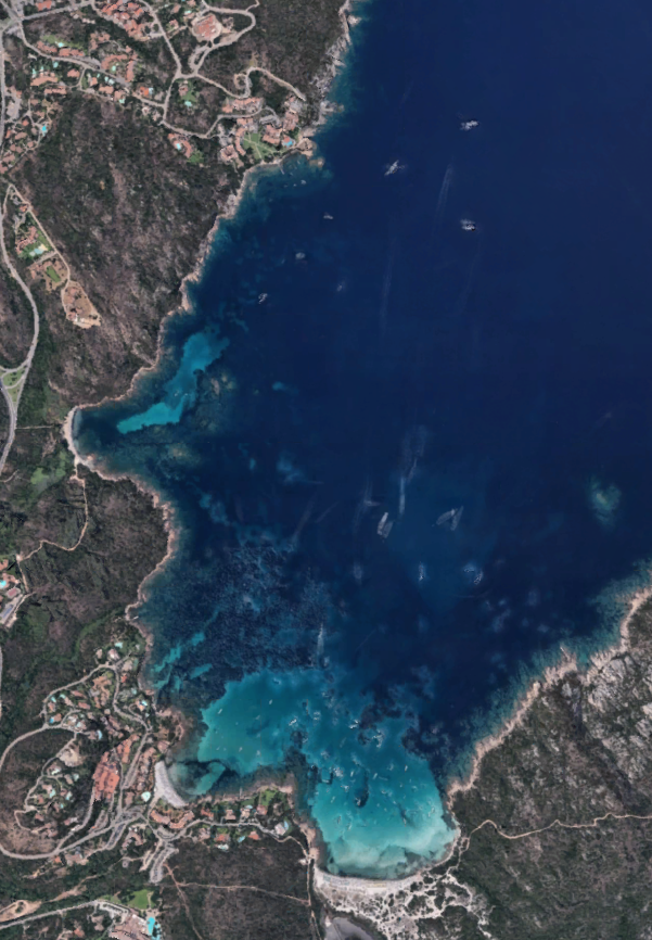
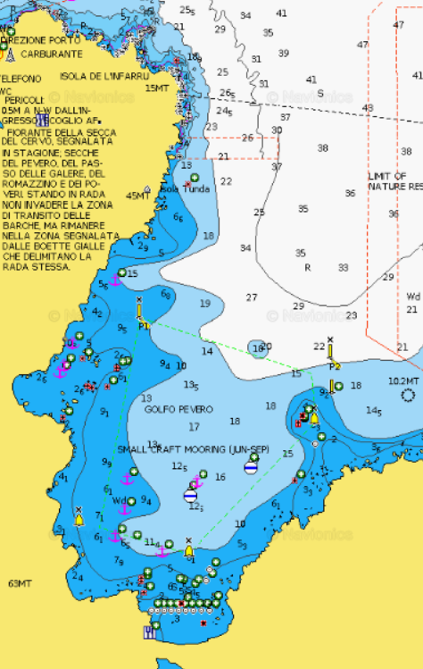
PORTO CERVO AREA - Pevero Bay
×
PORTO CERVO AREA - Pevero Bay
Beautiful spot with crystal clear water, white sand. Mooring field in the South of the bay, but free anchorage in the North part.
It offers protection from E, SE, S, SW, W, NW but open to NE; the bottom is sandy in the internal part and rocky with seaweeds in the first part of the gulf.
With W winds the best refuge is located near the coast, facing Cala Romantica. To access the beach there is a launching corridor, therefore once on the beach there is no easy access to the road.A Beach restaurant available ashore.GENERAL RESTRICTIONS:- Navigation within 200 m from the coast
- Anchoring within 200 m from the coast
- 10 knots speed limit within 1 km from the coast
- Running any craft within 200 m from the coast with engines on
- Tying lines to rocks
ANCHORAGE NAME PORTO CERVO AREA - PEVERO BAY COORDINATES 41°07'33.6"N9°32'58.7"E HIGHLIGHTS NATURAL BEAUTY, BUOY CAMP SHELTERED FROM E, SE, S, SW, W, NW LIMITS AND PROHIBITIONS BUOY CAMP SEABOTTOM SAND, ROCKS, SEAWEED FACILITIES TO LAND ASHORE YES FACILITIES ASHORE YES CLOSER DROP OFF POINT PORTO CERVO FUEL DOCK NEAREST COASTGUARD STATION PORTO CERVO -
PORTO CERVO AREA - Romazzino Bay
×
PORTO CERVO AREA - Romazzino Bay
Between emerald waters and verdant scented gardens, lies the Hotel Romazzino, a whitewashed building gently resting on a lengthy beach of the finest sand.
The bay, one of the most beautiful spots in Costa Smeralda, is the perfect corner that merges the beauty of the nature with the charme that Romazzino Hotel can offer.
The usage of the hotel pontoon is subject to Hotel authorization.GENERAL RESTRICTIONS:
- Navigation within 200 m from the coast
- Anchoring within 200 m from the coast
- 10 knots speed limit within 1 km from the coast
- Running any craft within 200 m from the coast with engines on
- Tying lines to rocks
VIEW MAPS ON: NAVIONICS.COM - GOOGLE EARTH
ANCHORAGE NAME ROMAZZINO BAY COORDINATES 41°05'52.7"N9°34'03.2"E HIGHLIGHTS ROMAZZINO HOTEL SHELTERED FROM N-NW-W WINDS LIMITS AND PROHIBITIONS NO FURTHER RESTRICTIONS SEABOTTOM SAND FACILITIES TO LAND ASHORE YES FACILITIES ASHORE YES CLOSER DROP OFF POINT ROMAZZINO HOTEL DOCK NEAREST COASTGUARD STATION PORTO CERVO -
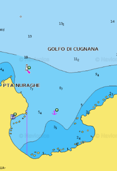
PORTO ROTONDO AREA - Cugnana Bay
×
PORTO ROTONDO AREA - Cugnana Bay
Cugnana Gulf, is a picturesque bay and natural harbor stretching from Punta Capriccioli in the north to Capo Figari in the south, encompassing the islands of Mortorio and Soffi, which are part of the Maddalena National Park. Nestled at the base of the Cugnana granite massif, rising to 650 meters, it serves as a haven for yachts, especially during mistral conditions, offering protection from prevailing winds in the area. This bay is renowned for its safety, situated between Poltu Quatu and Golfo Aranci, although caution is advised due to varying depths. The portion of Cugnana Gulf discussed here extends from Razza di Junco to Punta Volpe, providing not only secure anchorage during inclement weather but also opportunities for water sports, although maritime traffic should be taken into account. Additionally, it serves as a convenient logistical hub for guest transfers, being close to the airport, with several ports and marinas dotting its coastline, such as Porto Rotondo, Portisco, and Cala dei Sardi.GENERAL RESTRICTIONS:- Navigation within 200 m from the coast
- Anchoring within 200 m from the coast
- 10 knots speed limit within 1 km from the coast
- Running any craft within 200 m from the coast with engines on
- Tying lines to rocks
ANCHORAGE NAME PORTO ROTONDO AREA - CUGNANA BAY COORDINATES 41°2'11.23"N 9°31'55.57"E HIGHLIGHTS NATURAL BEAUTY SHELTERED FROM NW-SW-W WINDS LIMITS AND PROHIBITIONS NO FURTHER RESTRICTIONS SEABOTTOM SAND, SEAWEED FACILITIES TO LAND ASHORE YES FACILITIES ASHORE YES CLOSER DROP OFF POINT PORTISCO, CALA DEI SARDI, PORTO ROTONDO NEAREST COASTGUARD STATION PORTO ROTONDO -
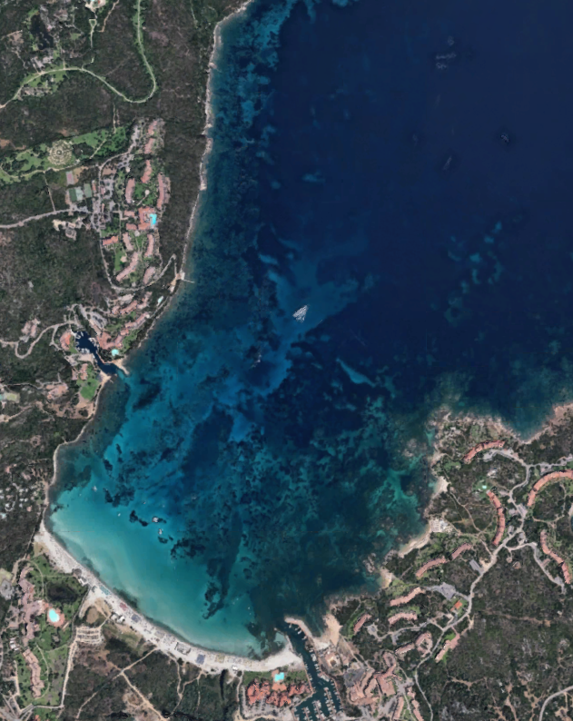
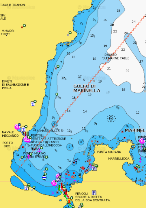
PORTO ROTONDO AREA - Gulf of Marinella
×
PORTO ROTONDO AREA - Gulf of Marinella
Situated in between Porto Rotondo and Golfo Aranci, Marinella bay offers a white sandy beach, fully equipped with tender and toy rental, beach bar and restaurants with a length of about 800 meters. It’s the largest beach you’ll find in this pocket of the Emerald Coast.Facing North-East, you can see the islands of Soffi and Mortorio 8 kilometers off the coast. Although there are several beach hotels spread around the area, Marinella's beach itself is backed by Mediterranean vegetation, with several trails leading to the beach. The main village of Marinella has its own harbour and yacht club. Marinella's beach is suitable for families with children, and protected from W winds.
Anchor at least at 200 metres from the last buoy of Marinella Buoy Camp.
Watersports are forbidden inside the Buoy Camp.GENERAL RESTRICTIONS:- Navigation within 200 m from the coast
- Anchoring within 200 m from the coast
- 10 knots speed limit within 1 km from the coast
- Running any craft within 200 m from the coast with engines on
- Tying lines to rocks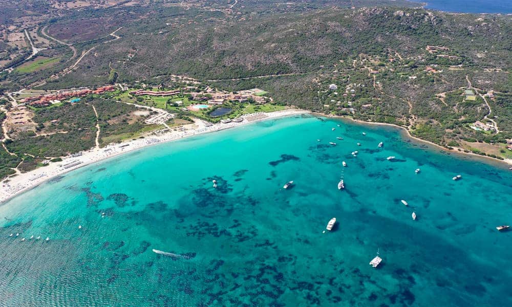
ANCHORAGE NAME PORTO ROTONDO AREA - GULF OF MARINELLA COORDINATES 41°0'53.54"N9°33'50.87"E HIGHLIGHTS NATURAL BEAUTY SHELTERED FROM NW-W-SW-S-SE WINDS LIMITS AND PROHIBITIONS NO WATERSPORTS INSIDE THE BUOY CAMP SEABOTTOM SAND FACILITIES TO LAND ASHORE YES FACILITIES ASHORE YES CLOSER DROP OFF POINT MARINELLA BUOY CAMP DOCK - MARANA DOCK NEAREST COASTGUARD STATION PORTO ROTONDO -
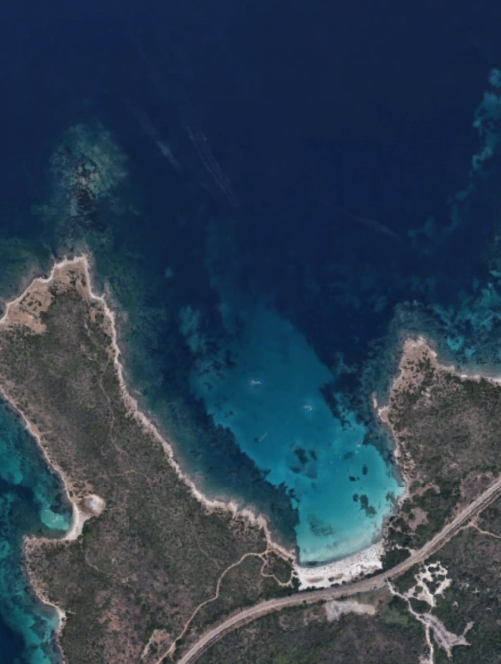
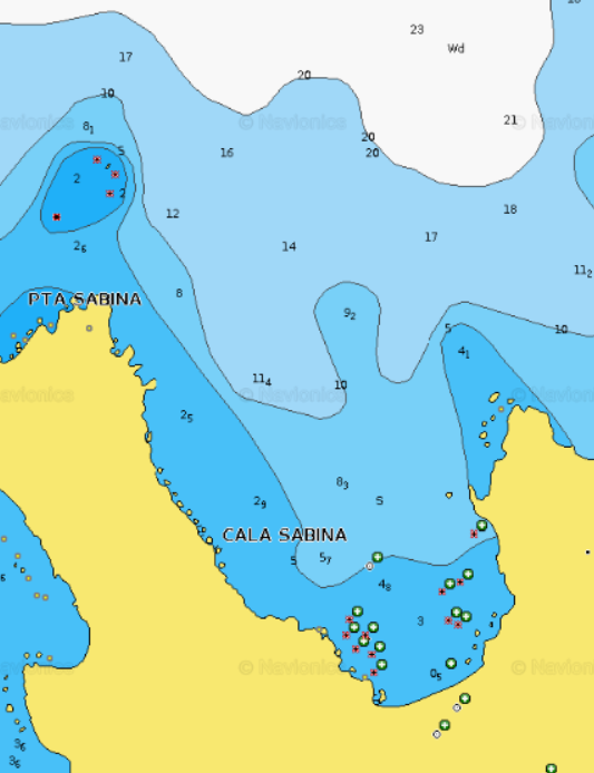
PORTO ROTONDO AREA - Cala Sabina
×
PORTO ROTONDO AREA - Cala Sabina
Cala Sabina beach (Spiaggia di Cala Sabina) is located in the Golfo Aranci area, along the railroad track that leads to the village. The train passes Stazione Cala Sabine three or four times a day. This Caribbean style beach is surrounded by Mediterranean greenery and juniper trees, faces north-west, offering a fabulous view of the emerald sea. Cala Sabina beach has a restaurant serving lunch and dinner, and from 18.00, the bar serves appetizers, and often a DJ plays at night to add to the atmosphere while you are dining on the beach. Due to its rise in popularity, Cala Sabina beach can get crowded in August, and is best visited in the early morning.Thanks to sandy low sea bottoms, the bay is an ideal destination for families with kids since children can safely play, bathe and have fun here.
Sheltered from westerly winds.GENERAL RESTRICTIONS:
- Navigation within 200 m from the coast
- Anchoring within 200 m from the coast
- 10 knots speed limit within 1 km from the coast
- Running any craft within 200 m from the coast with engines on
- Tying lines to rocks
VIEW MAPS ON: NAVIONICS.COM - GOOGLE EARTH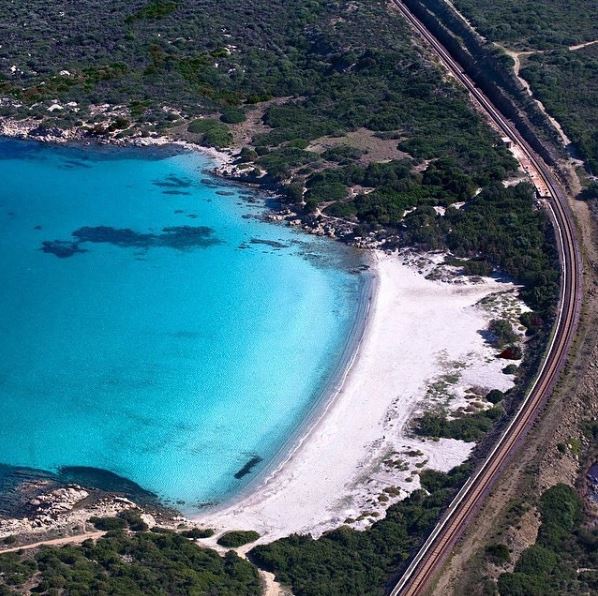
ANCHORAGE NAME OLBIA AREA - CALA SABINA COORDINATES 41°00'49.9"N 9°34'57.7"E HIGHLIGHTS NATURAL BEAUTY SHELTERED FROM W-SW-S-SE WINDS LIMITS AND PROHIBITIONS NO FURTHER RESTRICTIONS SEABOTTOM SAND FACILITIES TO LAND ASHORE NONE FACILITIES ASHORE YES CLOSER DROP OFF POINT PUNTA MARANA MARINA OFFICE AND/OR PORTO ORO NEAREST COASTGUARD STATION PORTO ROTONDO