e coast
from Orosei Gulf to Muravera
Anchorages
Hide MapIf you want to continue the navigation, please sign up
Request your temporary Access Code
This operational platform has been created to help yacht captains, yacht brokers, crew members, yacht agents and all people involved in the yachting industry to find in our DISCOVER SARDINIA section the right operational tool for cruising Sardinia. Nautica Assistance reserves the right to accept or decline the registration. Once accepted you will be receiving an access code with a validity of six months.
-
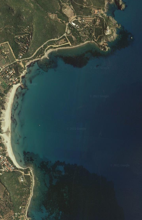
OROSEI AREA - Cala Ginepro
×

OROSEI AREA - Cala Ginepro
In the centre of the eastern coast of Sardinia, a juniper forest mixed with Mediterranean scrub reaches a stretch of sand that slopes into the clear blue sea. Cala Ginepro, gets its name from the small juniper forest situated by the coast. The cove is famous for its transparent waters and its beach with fine sand and pebbles, smoothed by the erosive action of the sea. The low, rounded rocks act as a border to several areas of the beach, making it look like an outdoor swimming pool. The shallow waters also makes it suitable for children's games. Long walks and sunsets filled with poetry make the cove one of the most poetic on the eastern coast, accompanied by the intense evening fragrance of the junipers. This windswept area is the ideal destination for surfers and it is very popular with those who like to do some underwater fishing or snorkelling. Sheltered from westerly winds. Beware, for those coming from N don't pull over immediately to the beach: the S side of the point is fringed with rocks (scoglio Marchesa).GENERAL RESTRICTIONS:- Navigation within 200 m from the coast
- Anchoring within 200 m from the coast
- 10 knots speed limit within 1 km from the coast
- Running any craft within 200 m from the coast with engines on
- Tying lines to rocks
ANCHORAGE NAME OROSEI AREA - CALA GINEPRO COORDINATES 40°26'48.60"N 9°47'43.86"E HIGHLIGHTS NATURAL BEAUTY SHELTERED FROM W-NW-N-NE WINDS LIMITS AND PROHIBITIONS NO FURTHER RESTRICTIONS SEABOTTOM SAND FACILITIES TO LAND ASHORE NONE FACILITIES ASHORE YES CLOSER DROP OFF POINT STAGNO PETROSU NEAREST COASTGUARD STATION OLBIA -
OROSEI AREA - Cala Luna
×
OROSEI AREA - Cala Luna
Cala Luna, in the gulf of Orosei, just south of Dorgali, is one of the most beautiful beaches in Sardinia.Set against a backdrop of steep limestone cliffs and lush greenery, its turquoise and azure blue waters are crystal clear, making it one of the best snorkeling beaches in the area.This secluded beach lies approximately 3 kilometers away from the Bue Marino Caves – a big sea cave with stalactites, stalagmites, and rock carvings – making Cala Luna the perfect spot for boat excursions.
A little dock is available to go ashore.Sheltered from W wind and very open to the E.GENERAL RESTRICTIONS:- Navigation within 200 m from the coast
- Anchoring within 200 m from the coast
- 10 knots speed limit within 1 km from the coast
- Running any craft within 200 m from the coast with engines on
- Tying lines to rocks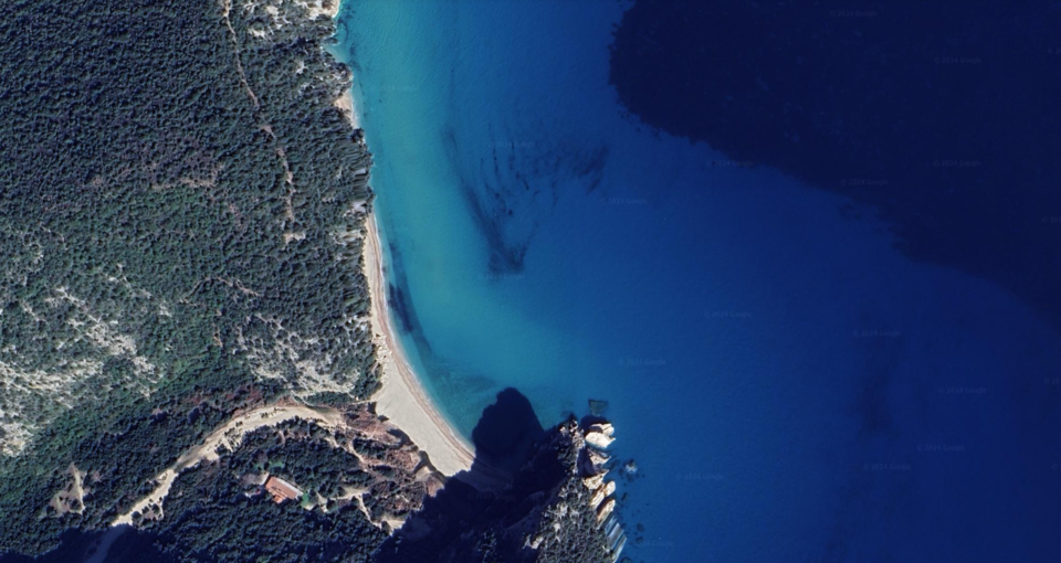
ANCHORAGE NAME OROSEI AREA - CALA LUNA COORDINATES 40°13'33.9"N 9°37'42.6"E HIGHLIGHTS NATURAL BEAUTY SHELTERED FROM SW-W-NW WINDS, OPEN TO E WIND LIMITS AND PROHIBITIONS NO FURTHER RESTRICTIONS SEABOTTOM SAND FACILITIES TO LAND ASHORE YES FACILITIES ASHORE NONE CLOSER DROP OFF POINT CALA GONONE FUEL DOCK NEAREST COASTGUARD STATION OLBIA -
OROSEI AREA - Cala Sisine
×
OROSEI AREA - Cala Sisine
Considered as the small pearl of the Orosei Gulf because of the wonderful high cliffs of Serra Ovra which gently slope to the sea from a height of over 500 metres. The whole bay is covered with Mediterranean maquis and surrounded by two rocky walls which, in their turn, make the place similar to a mountain rich of centuries-old carob tree and holm oaks. The bay is an ideal destination for scuba divers and anyone wishing to explore the local flora and fish fauna. Only 3NM south of Cala Luna.GENERAL RESTRICTIONS:- Navigation within 200 m from the coast
- Anchoring within 200 m from the coast
- 10 knots speed limit within 1 km from the coast
- Running any craft within 200 m from the coast with engines on
- Tying lines to rocks
ANCHORAGE NAME OROSEI AREA - CALA SISINE COORDINATES 40°10'48"N,9°38'9"E HIGHLIGHTS NATURAL BEAUTY SHELTERED FROM NW-W-SW WINDS LIMITS AND PROHIBITIONS NO FURTHER RESTRICTIONS SEABOTTOM SAND, PEBBLES FACILITIES TO LAND ASHORE NONE FACILITIES ASHORE NONE CLOSER DROP OFF POINT CALA GONONE FUEL DOCK NEAREST COASTGUARD STATION OLBIA -
OROSEI AREA - Cala Mariolu
×
OROSEI AREA - Cala Mariolu
A real jewel in the Gulf of Orosei, on the central-eastern coast of Sardinia.
Dive into this sea that looks painted. It is also known as ispùligi de nie (snow fleas) due to the small round, pink and white pebbles, mixed with sand.
The cliff surrounding this beach, reaches a height of 500 metres and looks out onto the sea both to the north and to the south, making Cala Mariolu accessible from the land only via a challenging trekking trail (for experts) through dense Mediterranean scrub.
Perfect spot for hiking and diving lovers.GENERAL RESTRICTIONS:- Navigation within 200 m from the coast
- Anchoring within 200 m from the coast
- 10 knots speed limit within 1 km from the coast
- Running any craft within 200 m from the coast with engines on
- Tying lines to rocks
ANCHORAGE NAME OROSEI AREA - CALA MARIOLU COORDINATES 40°7'30.77"N9°40'34.51"E HIGHLIGHTS NATURAL BEAUTY SHELTERED FROM W-SW-S WINDS LIMITS AND PROHIBITIONS NO FURTHER RESTRICTIONS SEABOTTOM SAND AND ROCKS FACILITIES TO LAND ASHORE NONE FACILITIES ASHORE NONE CLOSER DROP OFF POINT CALA GONONE, SANTA MARIA NAVARRESE NEAREST COASTGUARD STATION OLBIA -
OROSEI AREA - Cala Goloritzè
×
OROSEI AREA - Cala Goloritzè
Situated about three kilometres away from Capo Monte Santu, Punta Goloritzé and Punta Caroddi, Cala Goloritzé is so beautiful that it was declared Italy's National Monument in 1995. The bay offers wonderful beaches composed of a multitude of tiny white marble pebbles in addition to the 143-metre Aguglia and a natural arch on the right side of the cove. Moreover, a fresh water source falls out from the rocks inside the beach and flows into the sea.
Direct access to the beach is not permitted, anchor at 200mt from the coast, delimited by a line of floating buoys.
Perfect spot for hikes, trekkings.GENERAL RESTRICTIONS:- Navigation within 200 m from the coast
- Anchoring within 200 m from the coast
- 10 knots speed limit within 1 km from the coast
- Running any craft within 200 m from the coast with engines on
- Tying lines to rocks
ANCHORAGE NAME OROSEI AREA - CALA GOLORITZÈ COORDINATES 40°06'32.8"N9°41'25.1"E HIGHLIGHTS NATURAL BEAUTY SHELTERED FROM W-SW-S WINDS LIMITS AND PROHIBITIONS DIRECT ACCESS TO THE BEACH IS FORBIDDEN SEABOTTOM SAND FACILITIES TO LAND ASHORE NONE FACILITIES ASHORE NONE CLOSER DROP OFF POINT CALA GONONE FUEL DOCK NEAREST COASTGUARD STATION OLBIA -
SANTA MARIA NAVARRESE AREA - Pedra Longa
×
SANTA MARIA NAVARRESE AREA - Pedra Longa
A tall limestone 'pyramid' rising from the sea, a natural monument on the Ogliastra coast of Baunei, in central-eastern Sardinia, a destination for hikers and climbers.
Pedra Longa is actually a 'piece of mountain' fallen from the surrounding cliff, a link between the Gennargentu massif and the Gulf of Orosei. A calcareous-dolomitic block, an integral part (detached) of the vast Baunei plateau. Its 'spire' shape rises from the sea to a height of 128 metres: it is one of the highest rocky outcrops on the island, directly overlooking the sea, and was declared a natural monument in 1993.
Pedra Longa marks the start of the spectacular, wild Baunei coastline, one of the most striking stretches of the Mediterranean: 40 kilometres of limestone ramparts overlooking waters of shimmering hues, interrupted by coves of pebbles and furrowed by canyons that reach down to the sea, forming beaches of soft, white sand.GENERAL RESTRICTIONS:- Navigation within 200 m from the coast
- Anchoring within 200 m from the coast
- 10 knots speed limit within 1 km from the coast
- Running any craft within 200 m from the coast with engines on
- Tying lines to rocks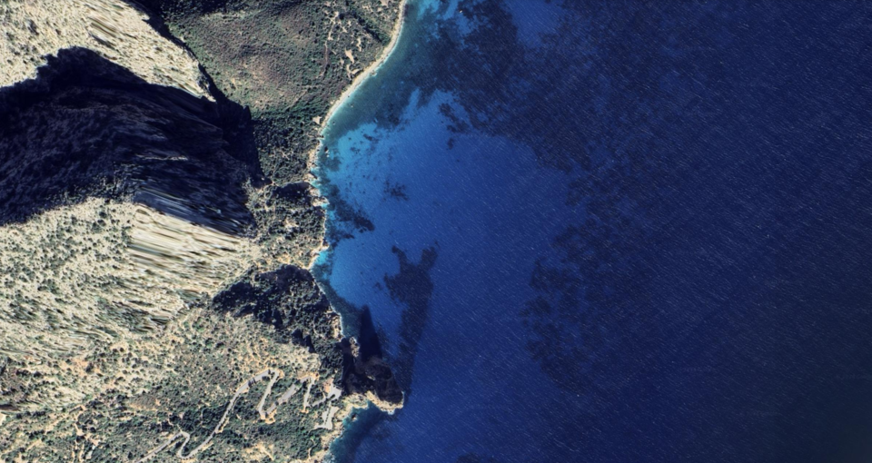
ANCHORAGE NAME SANTA MARIA NAVARRESE AREA - PEDRA LONGA COORDINATES 40°01'49"N9°42'23"E HIGHLIGHTS NATURAL BEAUTY SHELTERED FROM SW-W-NW WINDS LIMITS AND PROHIBITIONS NO FURTHER RESTRICTIONS SEABOTTOM ROCKS FACILITIES TO LAND ASHORE NONE FACILITIES ASHORE NONE CLOSER DROP OFF POINT MARINA DI BAUNEI & SANTA MARIA NAVARRESE NEAREST COASTGUARD STATION ARBATAX -
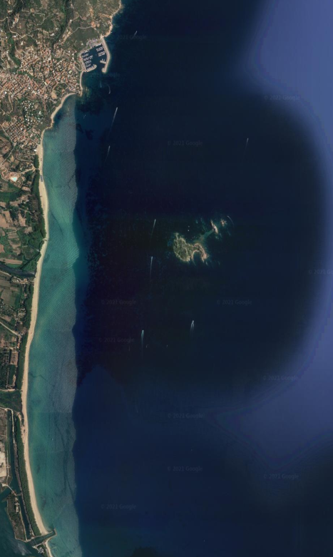
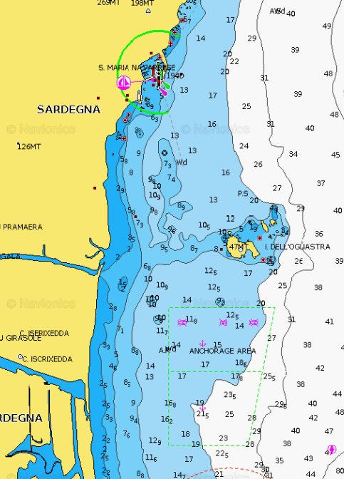
SANTA MARIA NAVARRESE AREA - Isola dell’Ogliastra
×
SANTA MARIA NAVARRESE AREA - Isola dell’Ogliastra
The small coastal town of Santa Maria Navarrese is situated on the dramatic east coast of Sardinia, approximately 145km from both Cagliari in the south and Olbia in the north east. The town has a lovely bay with town beach and marina, and a selection of shops, café bars, restaurants and pizzerias. The Supramonte Mountains provide a dramatic backdrop to the town. You can easily anchor anywhere in front of the long beach and get sheltered from Westerly winds.GENERAL RESTRICTIONS:- Navigation within 200 m from the coast
- Anchoring within 200 m from the coast
- 10 knots speed limit within 1 km from the coast
- Running any craft within 200 m from the coast with engines on
- Tying lines to rocks
ANCHORAGE NAME SANTA MARIA NAVARRESE AREA - ISOLA DELL’OGLIASTRA COORDINATES 39°58'56.0"N9°41'45.0"E HIGHLIGHTS NATURAL BEAUTY SHELTERED FROM SW-W-NW WINDS LIMITS AND PROHIBITIONS NO FURTHER RESTRICTIONS SEABOTTOM ROCKS, SEAWEED FACILITIES TO LAND ASHORE NONE FACILITIES ASHORE NONE CLOSER DROP OFF POINT MARINA DI BAUNEI NEAREST COASTGUARD STATION ARBATAX -
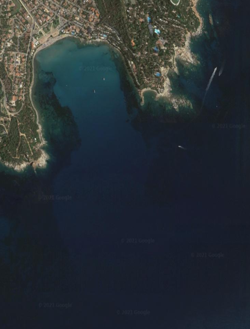
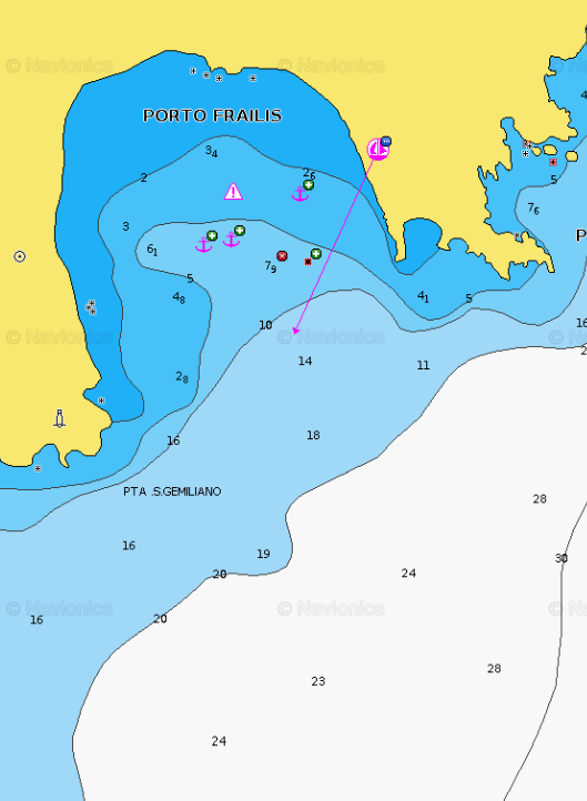
ARBATAX AREA - Porto Frailis
×
ARBATAX AREA - Porto Frailis
Just south of Capo Bellavista lies a charming cove, a picturesque bay sheltered from northand west winds. Its waters showcase varying shades of blue as sunlight dances across the sea, creating mesmerizing reflections.GENERAL RESTRICTIONS:- Navigation within 200 m from the coast
- Anchoring within 200 m from the coast
- 10 knots speed limit within 1 km from the coast
- Running any craft within 200 m from the coast with engines on
- Tying lines to rocks
ANCHORAGE NAME ARBATAX AREA - PORTO FRAILIS COORDINATES 39°55'21"N9°42'24"E HIGHLIGHTS NATURAL BEAUTY SHELTERED FROM W-NW-N-NE WINDS LIMITS AND PROHIBITIONS NO FURTHER RESTRICTIONS SEABOTTOM SAND FACILITIES TO LAND ASHORE NONE FACILITIES ASHORE YES CLOSER DROP OFF POINT MARINA DI ARBATAX NEAREST COASTGUARD STATION ARBATAX -
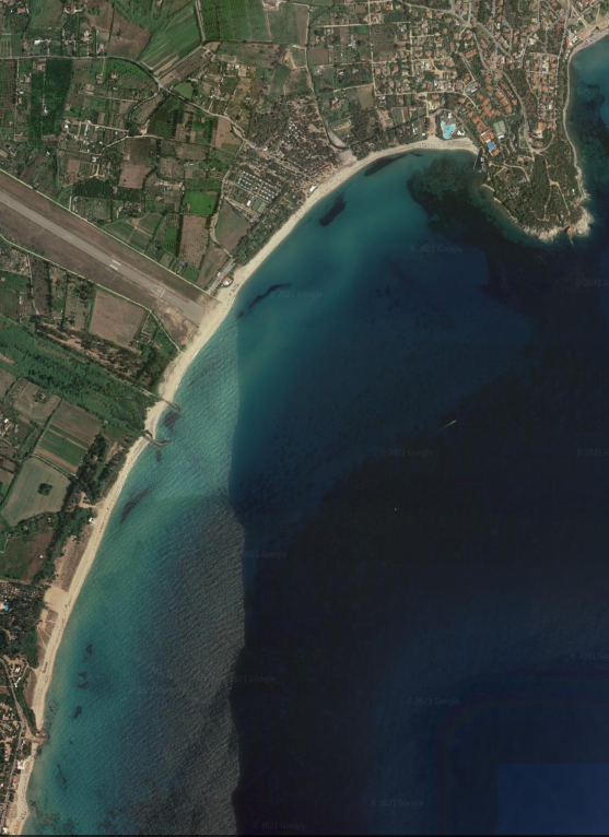
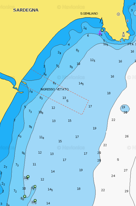
ARBATAX AREA - San Gemiliano
×
ARBATAX AREA - San Gemiliano
A paradise for surfers, San Gemiliano beach stretches over 2 km around the Gulf of St. Gemiliano, drawing a beautiful golden sandy bay.Dominated by the tower, the beach of San Gemiliano it's characterised by the dense vegetation of the Mediterranean scrub.A long beach bordered by beautiful trees and a magnificent open view of all the surrounding mountains.GENERAL RESTRICTIONS:- Navigation within 200 m from the coast
- Anchoring within 200 m from the coast
- 10 knots speed limit within 1 km from the coast
- Running any craft within 200 m from the coast with engines on
- Tying lines to rocks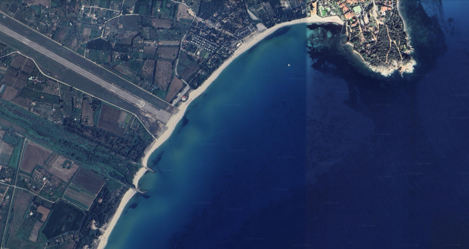
ANCHORAGE NAME ARBATAX AREA - SAN GEMILIANO COORDINATES 39°55'8"N9°41'50"E HIGHLIGHTS NATURAL BEAUTY SHELTERED FROM W-NW-N-NE WINDS LIMITS AND PROHIBITIONS NO FURTHER RESTRICTIONS SEABOTTOM SAND FACILITIES TO LAND ASHORE YES FACILITIES ASHORE YES CLOSER DROP OFF POINT ARBATAX MARINA NEAREST COASTGUARD STATION ARBATAX -
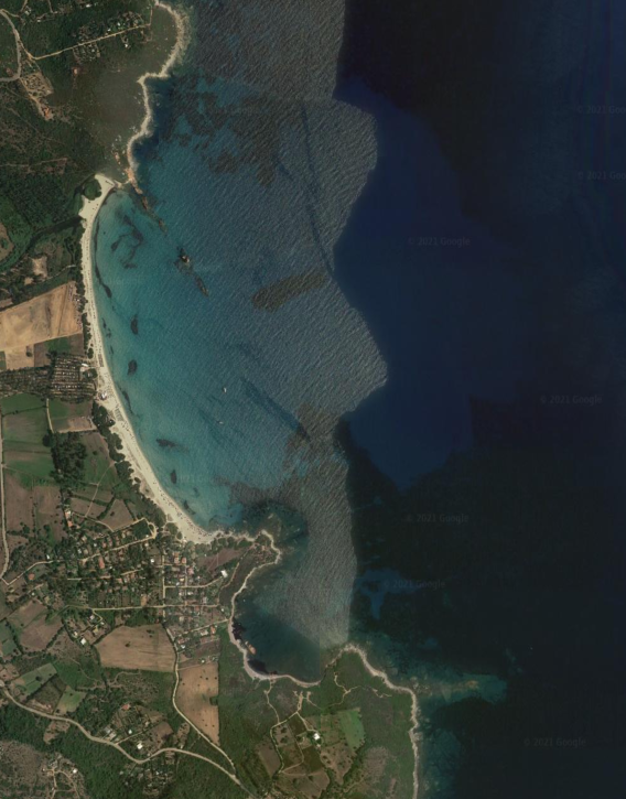
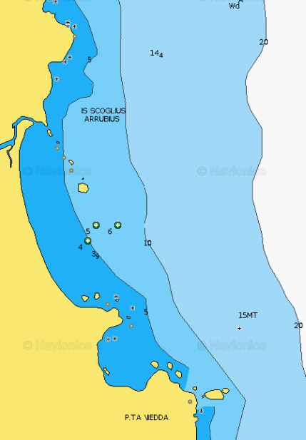
ARBATAX AREA - Cea Bay
×
ARBATAX AREA - Cea Bay
Cea beach is about 1 km long, made up of fine white sand. Bordered to the south by a strip of rocks (Punta Niedda), it is known for the presence, a few meters from the shore, of the beautiful red sea stacks (Is Scoglius Arrubius), besieged by those who want to dive into the clear sea of the beach.GENERAL RESTRICTIONS:- Navigation within 200 m from the coast
- Anchoring within 200 m from the coast
- 10 knots speed limit within 1 km from the coast
- Running any craft within 200 m from the coast with engines on
- Tying lines to rocks
ANCHORAGE NAME ARBATAX AREA - CEA BAY COORDINATES 39°52'12"N9°41'9"E HIGHLIGHTS NATURAL BEAUTY SHELTERED FROM SW-W WINDS LIMITS AND PROHIBITIONS NO FURTHER RESTRICTIONS SEABOTTOM SAND FACILITIES TO LAND ASHORE NONE FACILITIES ASHORE YES CLOSER DROP OFF POINT MARINA DI ARBATAX NEAREST COASTGUARD STATION ARBATAX -
MURAVERA AREA - Foxi Manna
×
MURAVERA AREA - Foxi Manna
Very nice bay with perfect sand bottom for anchorage, best to the North side. Very handy in the north side of the concrete dock to get ashore.GENERAL RESTRICTIONS:- Navigation within 200 m from the coast
- Anchoring within 200 m from the coast
- 10 knots speed limit within 1 km from the coast
- Running any craft within 200 m from the coast with engines on
- Tying lines to rocks
ANCHORAGE NAME FOXI MANNA COORDINATES 39°41'41"N9°39'46"E HIGHLIGHTS NATURAL BEAUTY SHELTERED FROM NW-W-SW WINDS LIMITS AND PROHIBITIONS NO FURTHER RESTRICTIONS SEABOTTOM SAND FACILITIES TO LAND ASHORE YES FACILITIES ASHORE YES CLOSER DROP OFF POINT FOXI MANNA CONCRETE DOCK NEAREST COASTGUARD STATION ARBATAX -
MURAVERA AREA - Murtas Beach
×
MURAVERA AREA - Murtas Beach
Beautiful bay whose white beach named from the wide mouth of the river that flows into it. It is 1 NM S capo Sferracavallo.
Anchorage during good weather, sheltered from W winds. Located east of Quirra, inside a military zone, it is 6 kilometers long.
Anchoring and reaching the beach is allowed only from June to September.
It is characterized by the presence of soft light beige sand dunes. The surrounding landscape is wild and evocative, with a scenario that combines sun and sea with birdwatching, biking and trekking and water sports. With a depth of around 15 meters (up to 25 meters) and rich in various fish species, this stretch of sea is particularly popular with those who love underwater fishing and diving. It is one of the wildest beaches in Sardinia, there are no facilities (bar or restaurants) available.
GENERAL RESTRICTIONS:
- Navigation within 200 m from the coast
- Anchoring within 200 m from the coast
- 10 knots speed limit within 1 km from the coast
- Running any craft within 200 m from the coast with engines on
- Tying lines to rocks
VIEW MAPS ON: NAVIONICS.COM - GOOGLE EARTH
ANCHORAGE NAME MURTAS BEACH COORDINATES 39°32'37"N9°38'39"E HIGHLIGHTS NATURAL BEAUTY SHELTERED FROM NW-W-SW WINDS LIMITS AND PROHIBITIONS NO FURTHER RESTRICTIONS SEABOTTOM SAND FACILITIES TO LAND ASHORE NONE FACILITIES ASHORE NONE CLOSER DROP OFF POINT PORTO CORALLO NEAREST COASTGUARD STATION ARBATAX -
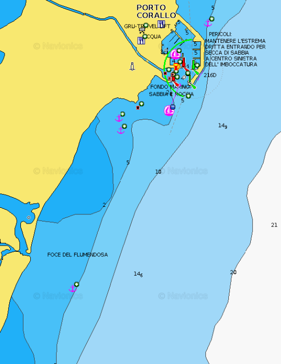
MURAVERA AREA - Porto Corallo
×
MURAVERA AREA - Porto Corallo
Anchorage in Porto Corallo is on the south side of the marina, along the beach, great protection from Westerly winds.GENERAL RESTRICTIONS:- Navigation within 200 m from the coast
- Anchoring within 200 m from the coast
- 10 knots speed limit within 1 km from the coast
- Running any craft within 200 m from the coast with engines on
- Tying lines to rocks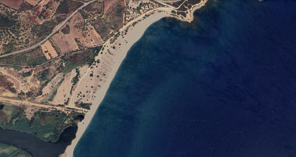
ANCHORAGE NAME PORTO CORALLO COORDINATES 39°25'55"N,9°38'4"E HIGHLIGHTS NATURAL BEAUTY SHELTERED FROM W-NW-SW WINDS LIMITS AND PROHIBITIONS NO FURTHER RESTRICTIONS SEABOTTOM SAND FACILITIES TO LAND ASHORE YES FACILITIES ASHORE NONE CLOSER DROP OFF POINT PORTO CORALLO MARINA NEAREST COASTGUARD STATION ARBATAX -
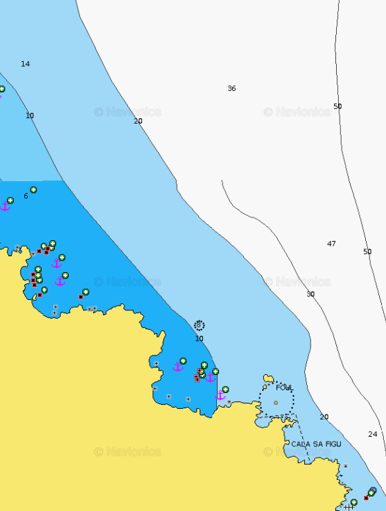
COSTA REI AREA - Cala Sa Figu
×
COSTA REI AREA - Cala Sa Figu
Beautiful place, excellent shelters from the SW. The path that climbs to the left of the beach offers a magnificent viewpoint.GENERAL RESTRICTIONS:
- Navigation within 200 m from the coast
- Anchoring within 200 m from the coast
- 10 knots speed limit within 1 km from the coast
- Running any craft within 200 m from the coast with engines on
- Tying lines to rocks
VIEW MAPS ON: NAVIONICS.COM - GOOGLE EARTH
ANCHORAGE NAME CALA SA FIGU COORDINATES 39°18'48"N,9°36'51"E HIGHLIGHTS NATURAL BEAUTY SHELTERED FROM W-SW-S WINDS LIMITS AND PROHIBITIONS NO FURTHER RESTRICTIONS SEABOTTOM SAND FACILITIES TO LAND ASHORE NONE FACILITIES ASHORE NONE CLOSER DROP OFF POINT PORTO CORALLO NEAREST COASTGUARD STATION CAGLIARI -
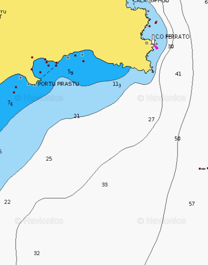
COSTA REI AREA - Capo Ferrato
×
COSTA REI AREA - Capo Ferrato
Nice anchorage on a sandy bottom from 4 to 7 m of clear water in front of a pebbles beach.In Capo Ferrato, the wild promontory is ideal for walking through dense pine forests, beautiful picnic benches invite you to take a break. For those looking for solitude, you can go and find a spot in one of the enchanting but rather steep and rocky mini-bays, which are found along the Capo Ferrato promontory.
Its southern side will surprise you with the quiet beach of Portu Pirastu, perfect for relaxing and snorkeling.
The peculiarity of this fine gravel beach is the configuration of its seabed: small sandbanks alternate with flat and shiny stones, constantly changing the colors of the water.GENERAL RESTRICTIONS:- Navigation within 200 m from the coast
- Anchoring within 200 m from the coast
- 10 knots speed limit within 1 km from the coast
- Running any craft within 200 m from the coast with engines on
- Tying lines to rocks
ANCHORAGE NAME COSTA REI AREA - CAPO FERRATO COORDINATES 39°17'24"N,9°36'21"E HIGHLIGHTS NATURAL BEAUTY SHELTERED FROM W-NW-N-NE WINDS LIMITS AND PROHIBITIONS NO FURTHER RESTRICTIONS SEABOTTOM SAND FACILITIES TO LAND ASHORE NONE FACILITIES ASHORE NONE CLOSER DROP OFF POINT PORTO CORALLO NEAREST COASTGUARD STATION CAGLIARI -
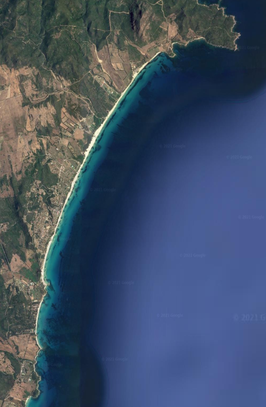
COSTA REI AREA - Costa Rei
×
COSTA REI AREA - Costa Rei
Costa Rei is a location in southern Sardinia between the municipalities of Muravera, Castiadas and Villasimius. Geographically it is bordered to the north by Capo Ferrato and to the south by the Peppino rock united by an uninterrupted beach of more than 7 km in length and characterized by the white color and the medium-fine sand particle size. Known for the exceptional transparency of its waters, it is a favorite destination for all the Sardinian travelers who are fond of snorkeling and diving.
Exploring further south find the Marine Protected Area of Capo Carbonara, the particular morphology of the coast offers fantastic trips into the coves like Cala Sa Figu, Portu S’Ilixi, Punta Molentis, Punta Proceddus and the depths of the Island of Serpentara and Cavoli Island. The slightly hilly landscapes of the hinterland are suitable for mountain biking or trekking with unmissable panoramic views of the sea from above, the surrounding woods and interesting archaeological remains.
The commercial squares offer the tasting of the best local food and wine products from all over Sardinia.GENERAL RESTRICTIONS:
- Navigation within 200 m from the coast
- Anchoring within 200 m from the coast
- 10 knots speed limit within 1 km from the coast
- Running any craft within 200 m from the coast with engines on
- Tying lines to rocks
VIEW MAPS ON: NAVIONICS.COM - GOOGLE EARTH
ANCHORAGE NAME COSTA REI COORDINATES 39°15'13"N,9°34'40"E HIGHLIGHTS NATURAL BEAUTY SHELTERED FROM NW-W-SW WINDS LIMITS AND PROHIBITIONS NO FURTHER RESTRICTIONS SEABOTTOM SAND FACILITIES TO LAND ASHORE YES FACILITIES ASHORE YES CLOSER DROP OFF POINT PISCINA REI - CAMPING LE DUNE NEAREST COASTGUARD STATION CAGLIARI -
COSTA REI AREA - Cala Sinzias
×
COSTA REI AREA - Cala Sinzias
Cala Sinzias is a large and pleasant inlet, on the southeastern coast of Sardinia.Immediately to the S of the renowned Costa Rei, it is approximately 8 miles SSW of Capo Ferrato and 7 miles NNE of Capo Carbonara (Villasimius). Coming from the N, pay attention to the Scoglio di Sant'Elmo, which protrudes about 600 m from the coast. The bay is bounded to the S by Punta is Cappuccinus, which provides good shelter from W and SW winds and partial shelter from moderate SE winds. However, keep in mind that the inlet is very open and as soon as the sirocco increases in intensity, an annoying surf tends to creep in.Even if Cala Sinzias seems to be sheltered also from N and NW winds, in reality it is not the best inlet to find shelter from them, even when moderate.
GENERAL RESTRICTIONS:- Navigation within 200 m from the coast
- Anchoring within 200 m from the coast
- 10 knots speed limit within 1 km from the coast
- Running any craft within 200 m from the coast with engines on
- Tying lines to rocks
VIEW MAPS ON: NAVIONICS.COM - GOOGLE EARTH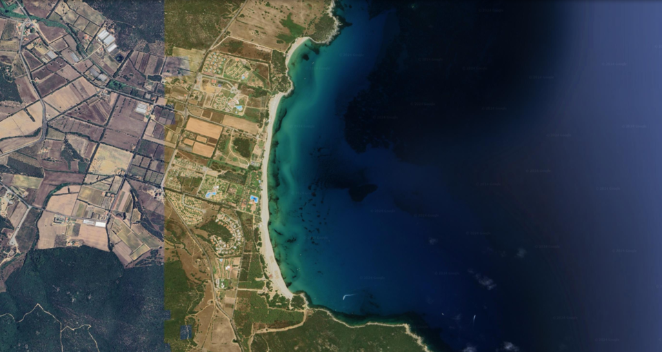
ANCHORAGE NAME COSTA REI AREA - CALA SINZIAS COORDINATES 39°11'32"N,9°34'6"E HIGHLIGHTS NATURAL BEAUTY SHELTERED FROM N-NW-SW-S WINDS LIMITS AND PROHIBITIONS NO FURTHER RESTRICTIONS SEABOTTOM SAND FACILITIES TO LAND ASHORE YES FACILITIES ASHORE YES CLOSER DROP OFF POINT LIDO TAMATETE NEAREST COASTGUARD STATION CAGLIARI -
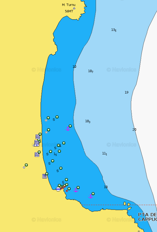
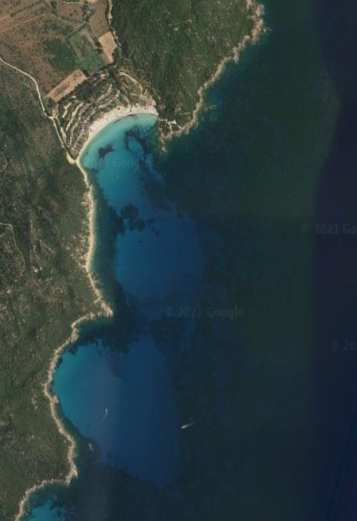
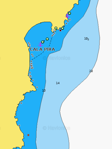
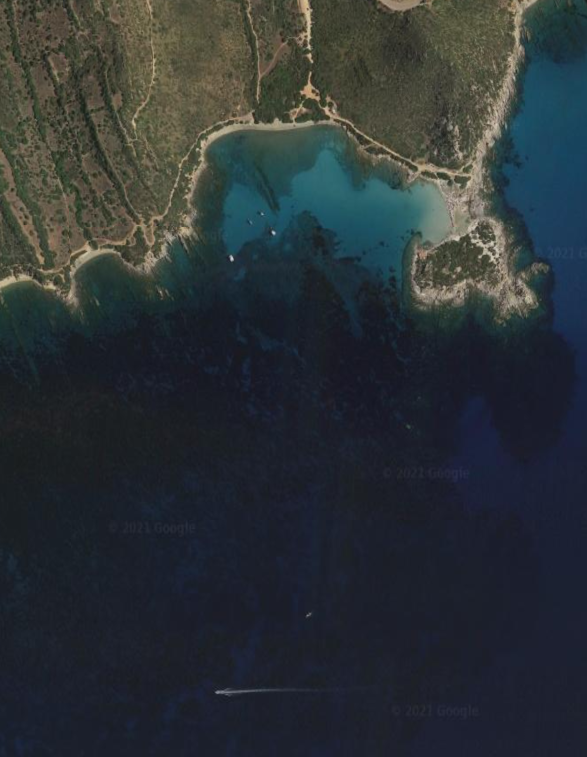
COSTA REI AREA - Cala Pira
×
COSTA REI AREA - Cala Pira
Cala Pira is a quiet place to enjoy an unforgettable sea and a seaside tranquility, suitable for the whole family. Cala Pira has a good holding in sand 5-8m, with crystal clear waters that makes it easy to spot if the anchor is well digged in, avoid with southerly and easterly winds.GENERAL RESTRICTIONS:- Navigation within 200 m from the coast
- Anchoring within 200 m from the coast
- 10 knots speed limit within 1 km from the coast
- Running any craft within 200 m from the coast with engines on
- Tying lines to rocks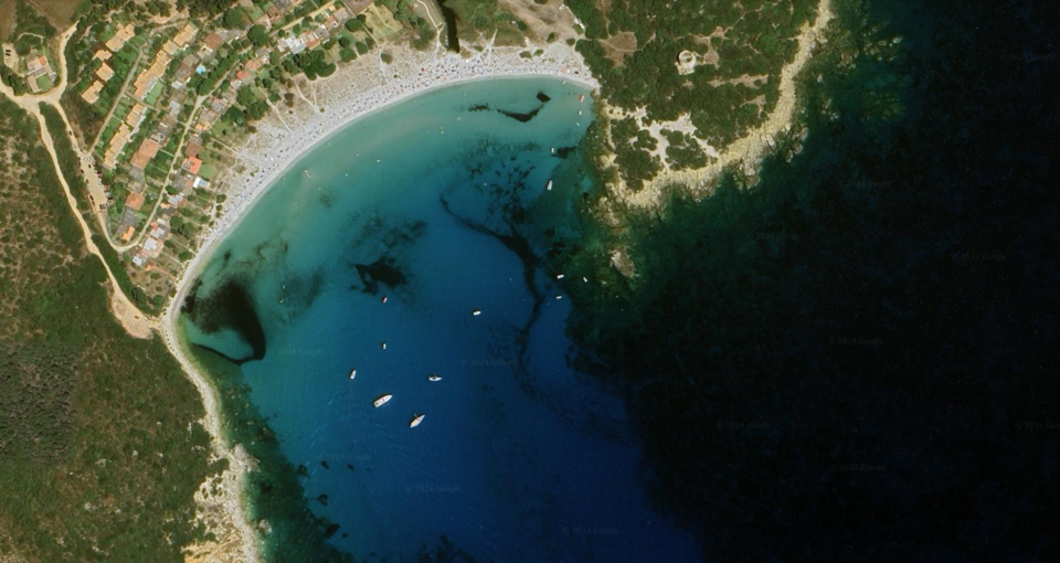
ANCHORAGE NAME COSTA REI AREA - CALA PIRA COORDINATES 39°10'14"N9°34'21"E HIGHLIGHTS NATURAL BEAUTY SHELTERED FROM N-NW-W-SW WINDS LIMITS AND PROHIBITIONS NO FURTHER RESTRICTIONS SEABOTTOM SAND FACILITIES TO LAND ASHORE YES FACILITIES ASHORE NONE CLOSER DROP OFF POINT CALA PIRA SPORTING YACHT CLUB NEAREST COASTGUARD STATION CAGLIARI -
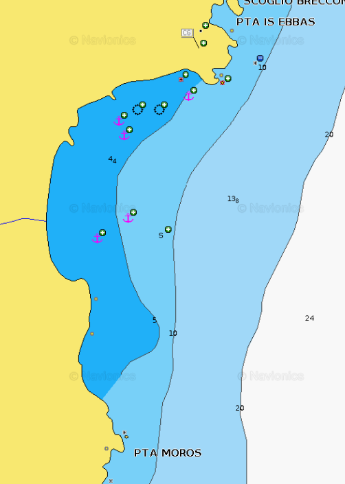
VILLASIMIUS AREA - Punta Molentis (Capo Carbonara Natural Park)
×
VILLASIMIUS AREA - Punta Molentis (Capo Carbonara Natural Park)
Punta Molentis is a very pleasant inlet bordered to the E by the beautiful granite suggestive rocks, to the NE by a small white sand beach, very popular among the local tourism and to the North by a small stone beach.Punta Molentis promontory and the beach are part of the Marine Protected Area of Capo Carbonara and owe the name to "su molenti", the donkey, once transporting the material extracted from the surrounding granite quarries. Punta Molentis is a pleasant anchorage, sheltered by NE breezes, the anchorage is pleasant and peaceful, in calm sea and wind conditions.In case of NW breezes move to Porto Giunco, NE of Capo Carbonara and anchor with 5-7 m depth.The water is crystal clear with an incredible blue, a swim is a must!GENERAL RESTRICTIONS:- Navigation within 200 m from the coast
- Anchoring within 200 m from the coast
- 10 knots speed limit within 1 km from the coast
- Running any craft within 200 m from the coast with engines on
- Tying lines to rocks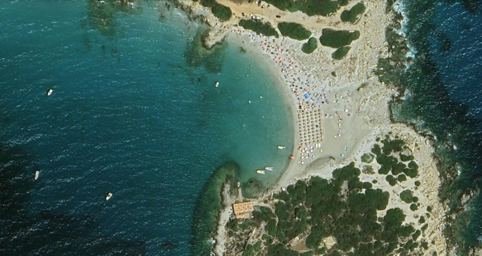
ANCHORAGE NAME VILLASIMIUS AREA - PUNTA MOLENTIS COORDINATES 39º08’00”N9º33’17”E HIGHLIGHTS NATURAL BEAUTY SHELTERED FROM N-NW-W-SW WINDS LIMITS AND PROHIBITIONS SEE CAPO CARBONARA ZONING MAP & REGULATIONS SEABOTTOM SAND FACILITIES TO LAND ASHORE NONE FACILITIES ASHORE YES CLOSER DROP OFF POINT VILLASIMIUS MARINA NEAREST COASTGUARD STATION CAGLIARI -
VILLASIMIUS AREA - Porto Giunco (Capo Carbonara Natural Park)
×
VILLASIMIUS AREA - Porto Giunco (Capo Carbonara Natural Park)
Porto Giunco beach is located in the south-east side of Capo Carbonara, under Porto Giunco Aragonese Tower. Behind the beach, there is the Stagno di Notteri, a place pink flamingos have chosen as their habitat. It is one of the many natural attractions in the marine protected area.Beautiful white sand beach, sheltered from the West, and from the South, sandy bottom, crystal clear water.Any anchorage point in the bay offers a good holding on sand and seagrass bottom.
GENERAL RESTRICTIONS:
- Navigation within 200 m from the coast
- Anchoring within 200 m from the coast
- 10 knots speed limit within 1 km from the coast
- Running any craft within 200 m from the coast with engines on
- Tying lines to rocks
VIEW MAPS ON: NAVIONICS.COM - GOOGLE EARTH
ANCHORAGE NAME VILLASIMIUS AREA - PORTO GIUNCO COORDINATES 39°6'59"N9°31'31"E HIGHLIGHTS NATURAL BEAUTY SHELTERED FROM NW-W-SW WINDS LIMITS AND PROHIBITIONS SEE CAPO CARBONARA ZONING MAP & REGULATIONS SEABOTTOM SAND, SEAWEED FACILITIES TO LAND ASHORE YES FACILITIES ASHORE YES CLOSER DROP OFF POINT VILLASIMIUS MARINA NEAREST COASTGUARD STATION CAGLIARI -
VILLASIMIUS AREA - Campulongu (Capo Carbonara Natural Park)
×
VILLASIMIUS AREA - Campulongu (Capo Carbonara Natural Park)
Very nice anchorage over perfect good holding in 4/10 m (average depth 5 m) of sand, with protection from NW to SE.Nice swim to the beach. This bay is located just after the exit of the Marina of Villasimius. An hotel located on the beautiful sandy beach is a good landmark.It is a pleasant anchorage with clear transparent water.
GENERAL RESTRICTIONS:
- Navigation within 200 m from the coast
- Anchoring within 200 m from the coast
- 10 knots speed limit within 1 km from the coast
- Running any craft within 200 m from the coast with engines on
- Tying lines to rocks
VIEW MAPS ON: NAVIONICS.COM - GOOGLE EARTH
ANCHORAGE NAME VILLASIMIUS AREA - CAMPULONGU COORDINATES 39°7'37"N9°30'18"E HIGHLIGHTS NATURAL BEAUTY SHELTERED FROM N-NW-NE-E-SE WINDS LIMITS AND PROHIBITIONS SEE CALA CARBONARA ZONING MAP & REGULATIONS SEABOTTOM SAND FACILITIES TO LAND ASHORE YES FACILITIES ASHORE YES CLOSER DROP OFF POINT VILLASIMIUS MARINA NEAREST COASTGUARD STATION CAGLIARI